Heritage & Archaeology
Drone Archaeological Survey Services
Reveal hidden archaeological features with precision aerial surveys. From crop marks to thermal imaging, our drone technology uncovers what traditional methods miss.
Response within 2 hours • Or call 020 4634 0456
What Is a Drone Archaeological Survey?
A drone archaeological survey uses advanced aerial technology to detect, record, and map archaeological features that are invisible or difficult to see from ground level. Our UAVs capture high-resolution imagery and data that reveal crop marks, earthworks, and buried structures across the landscape.
At Drone Survey Services, we combine photogrammetry, multispectral imaging, and thermal sensing to create comprehensive archaeological records. This non-invasive approach preserves the integrity of sites while providing archaeologists with detailed survey data for research, planning applications, and heritage management.

James Leslie
Owner, Engineer & Drone Pilot
"Got questions? Call me directly - I'm happy to talk through your project."
Call NowReveal Hidden History,Non-Invasively
What You'll Receive
- High-resolution site orthomosaic
- 3D terrain and feature models
- Crop mark analysis report
- CAD-ready survey drawings
Delivered in 5-7 working days
Why Choose Us
- CAA approved & fully insured
- Experience with heritage projects
- Latest drone & sensor technology
- UK-wide coverage
Trusted by archaeology units, heritage organisations and consultancies across the UK.
Trusted by leading organisations
How Much Does a Drone Archaeological Survey Cost?
Pricing depends on your project scope and requirements. Here's a guide to help you budget:
| Project Size | Guide Price |
|---|---|
| Small SiteUnder 1 ha | £500+ |
| Medium Site1–5 ha | £900+ |
| Large Site5–20 ha | £1,800+ |
| Major Site20+ ha | POA |
| Research ProjectsAcademic/heritage | POA |
*Guide prices include standard deliverables. Final quote based on site complexity, access, and specific requirements.
What affects your quote?
- Site size & terrain
- Required deliverables
- Turnaround time
- Sensor requirements
Our drone-based approach typically saves 40–60% compared to traditional ground survey methods while covering sites far more quickly. Contact us with your project details and we'll provide a tailored quote within 24 hours.
Ready to get a quote for your project?
Free, no-obligation quotes within 24 hours
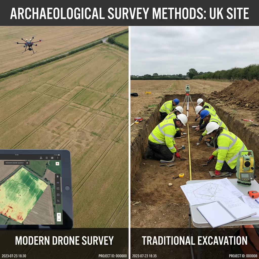
What Is the Difference Between Drone Archaeological Survey and Traditional Methods?
Traditional archaeological survey relies on ground-based techniques like total station recording, GPS plotting, and manual photography. While accurate, these methods are time-consuming, weather-dependent, and limited in the perspective they can offer.
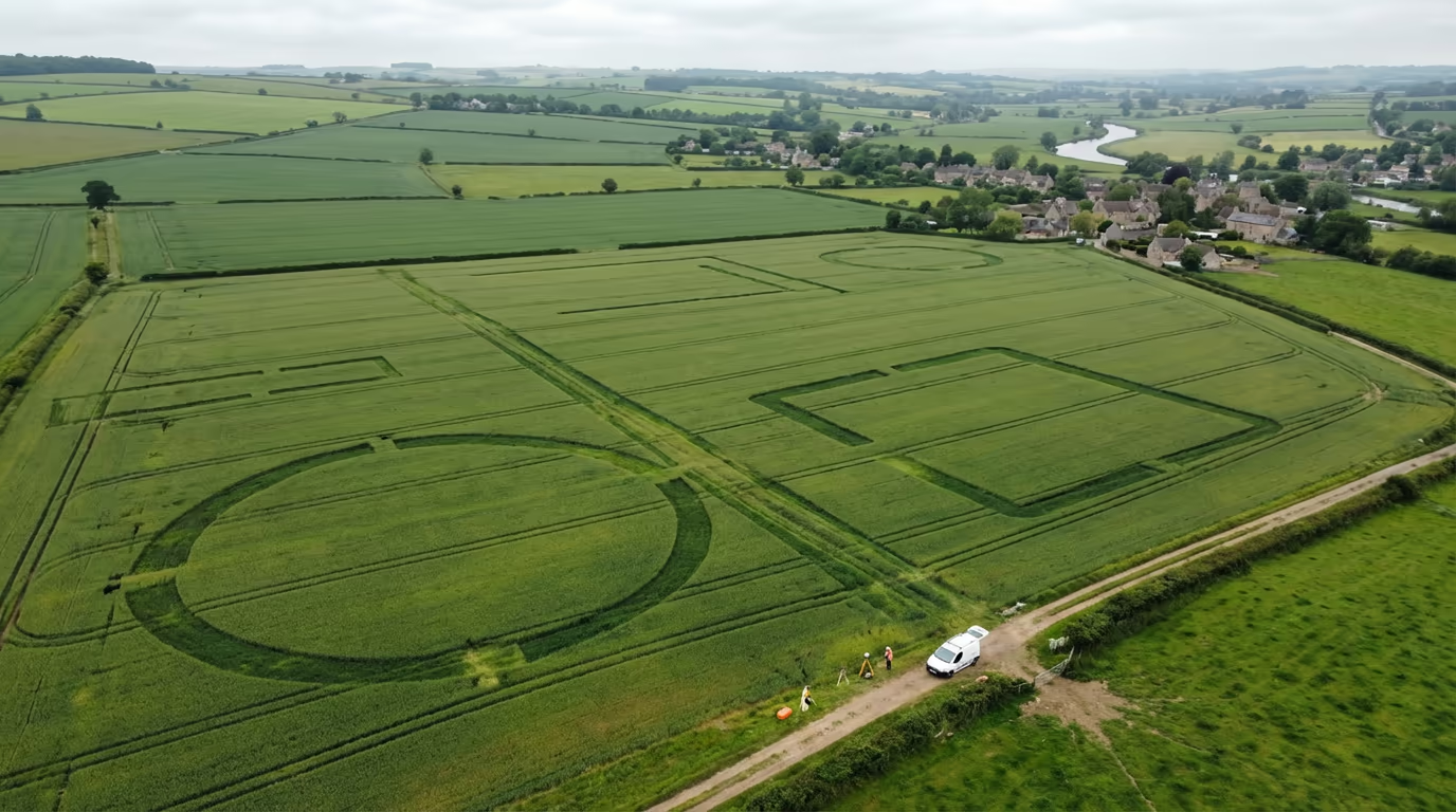
Drone archaeological survey captures the entire site from above in a fraction of the time, revealing patterns and features that are simply invisible from ground level. Crop marks, subtle earthworks, and landscape relationships become immediately apparent when viewed from altitude.
When to Choose Each Approach
Choose Drone Archaeological Survey
Landscape-scale insight
Choose Traditional Methods
Precise detail recording
Not sure which approach suits your project?
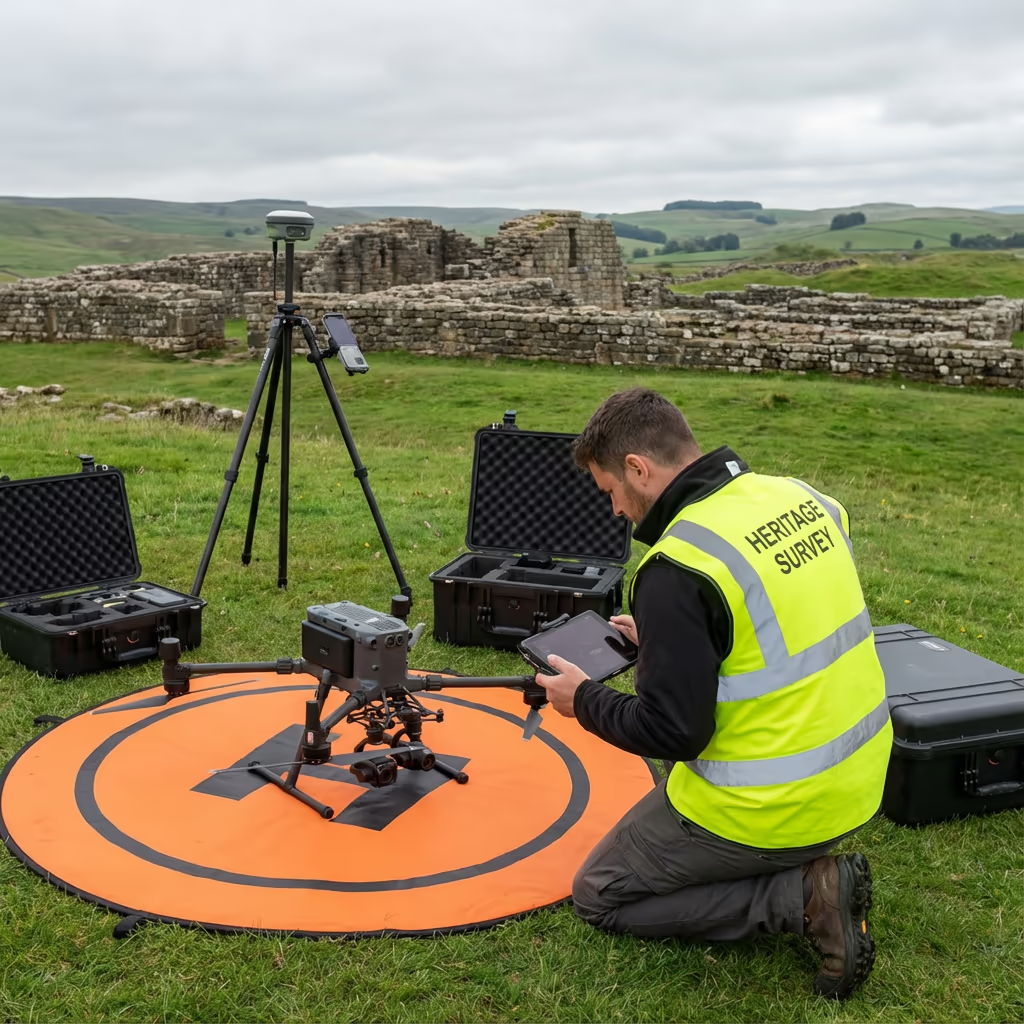
What Accuracy Can a Drone Archaeological Survey Achieve?
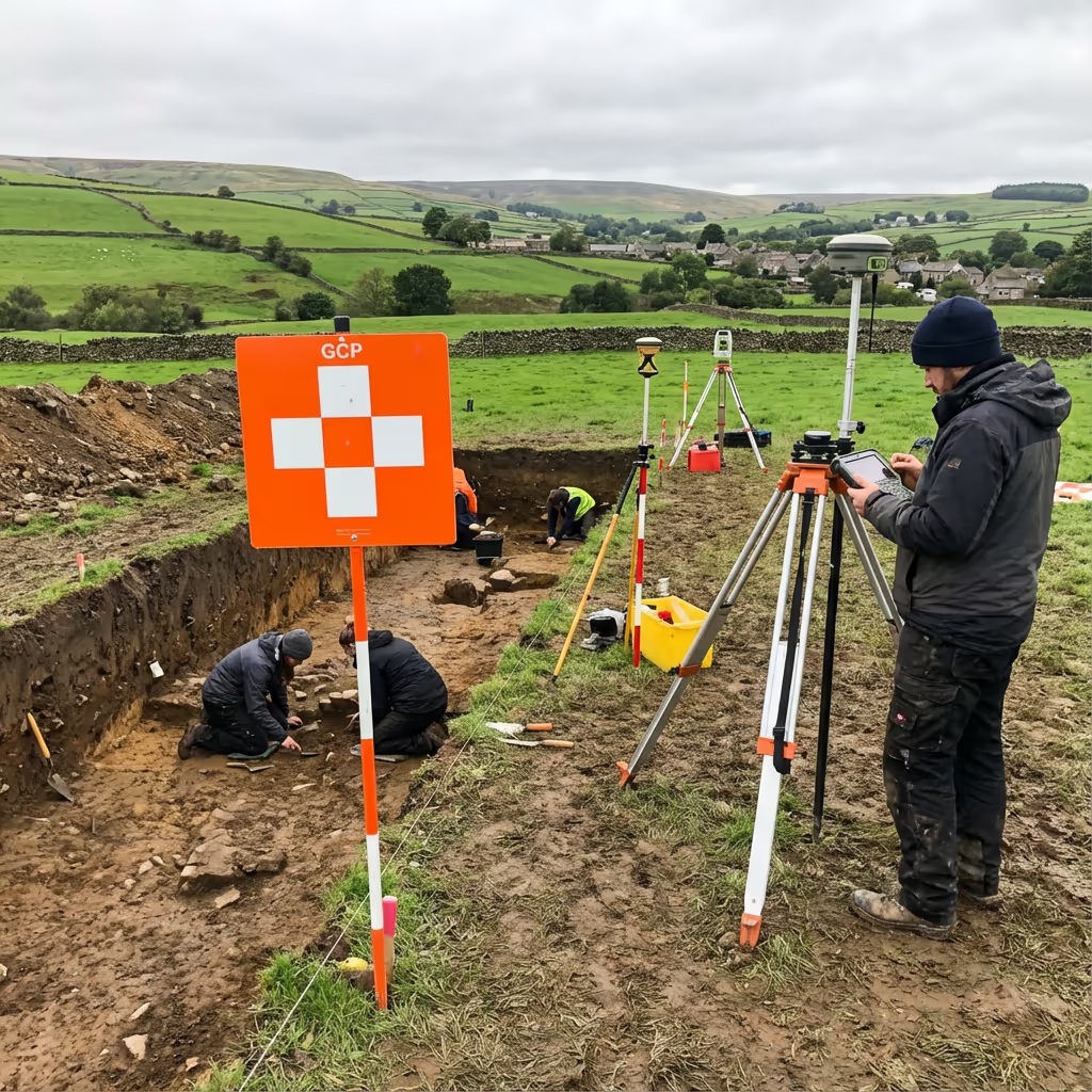
Our drone archaeological surveys achieve positional accuracy of ±2-3cm when using ground control points—meeting or exceeding the standards required for most archaeological recording. Ground sample distances of 1-2cm per pixel ensure individual features are clearly visible and measurable.
We use RTK-enabled drones with survey-grade GNSS positioning, combined with carefully distributed ground control points measured with our own GPS equipment. This workflow produces georeferenced outputs that integrate seamlessly with your existing site records and national grid references.
What Are the Applications of Drone Archaeological Survey?
Drone archaeological survey has transformed heritage recording across numerous applications. Here are the key areas where our clients see the greatest value:
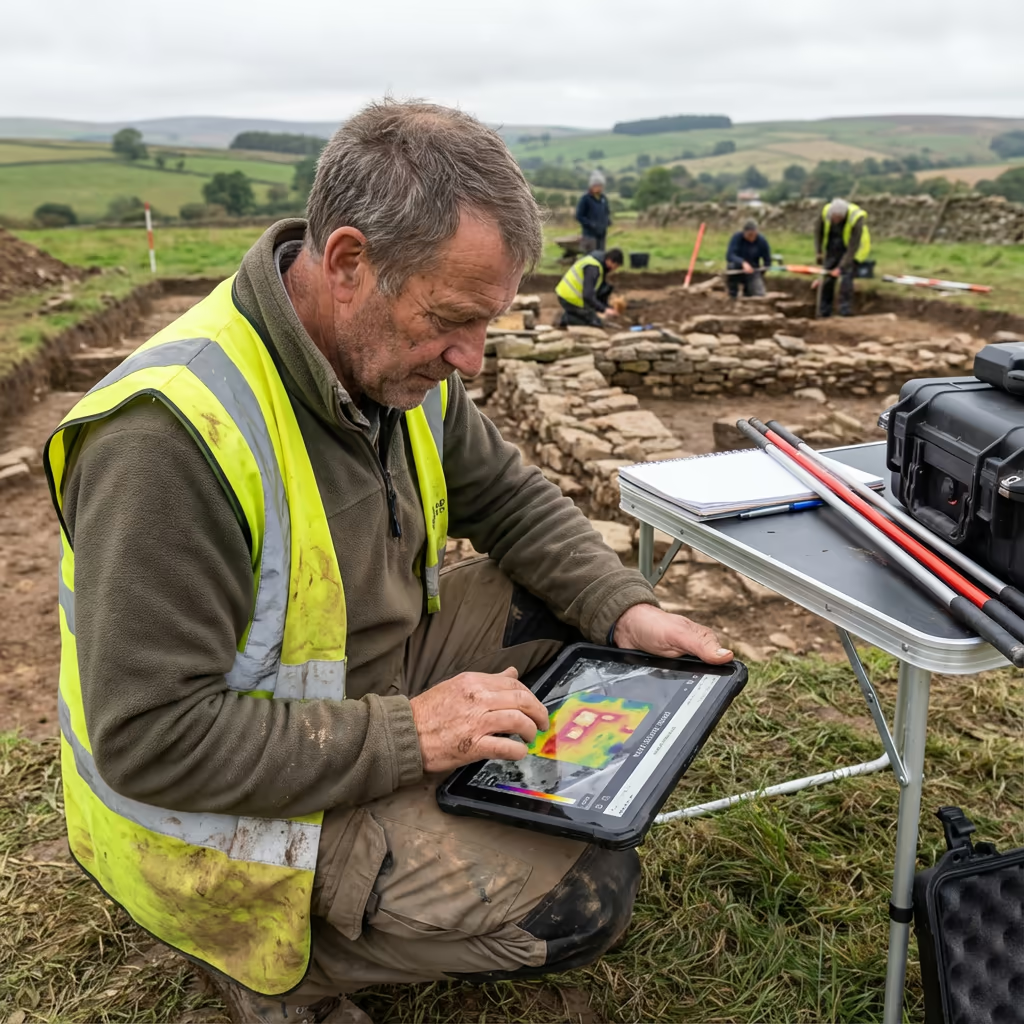
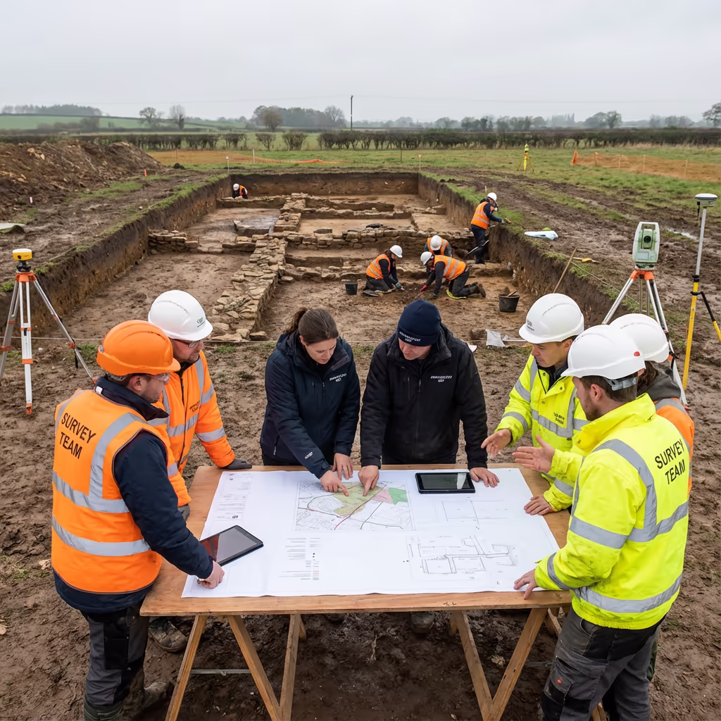
Excavation Recording
Comprehensive photographic records of trenches and open-area excavations, with precise 3D models for post-excavation analysis.
Desk-Based Assessments
High-resolution aerial imagery to support heritage impact assessments and planning applications.
Crop Mark Surveys
Targeted surveys during optimal conditions to detect and record buried archaeological features visible as crop marks.
Monument Recording
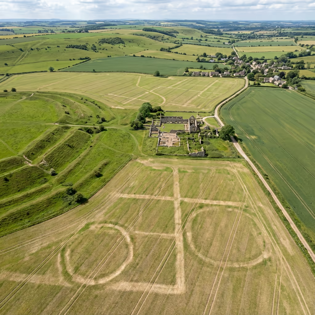
Detailed recording of scheduled monuments, hillforts, barrows, and other protected sites for condition monitoring.
Landscape Surveys
Wide-area surveys to understand settlement patterns, field systems, and the relationship between features.
Community Projects
Supporting HLF-funded projects, research excavations, and community archaeology initiatives with professional survey data.
Have an archaeological project that needs surveying?
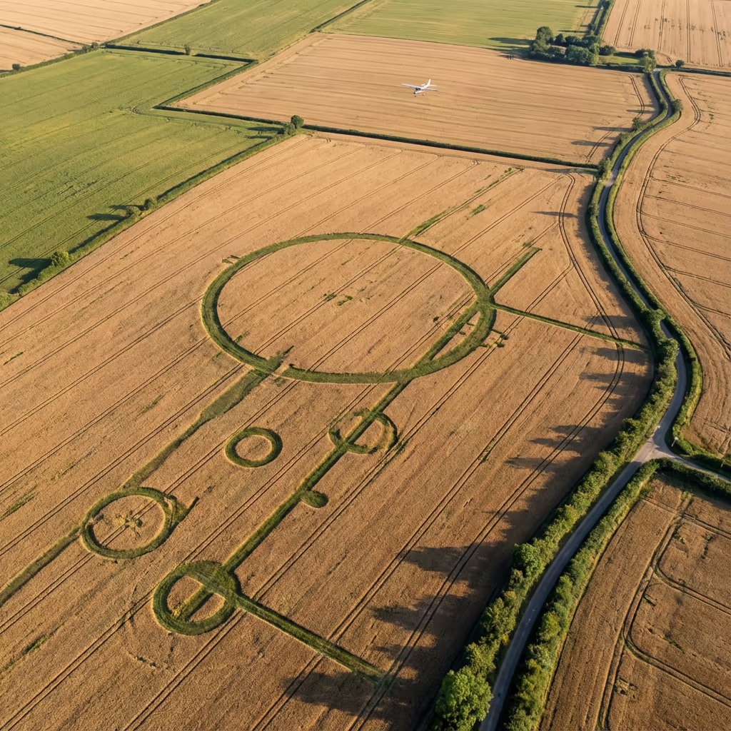
Can Drones Reveal Hidden Archaeological Features?
Absolutely—this is one of the most powerful applications of drone archaeological survey. Features buried beneath the surface can become visible through several phenomena that are best observed from the air.
Crop marks form when buried ditches retain more moisture, causing crops above to grow taller and remain green longer. Conversely, buried walls and floors restrict root growth, creating stunted or stressed vegetation. Our drones capture these subtle differences during optimal conditions—typically early summer mornings after dry spells.
How We Detect Hidden Features
Crop Mark Analysis
Standard RGB imagery during optimal growing conditions reveals differential crop growth patterns above buried features.
Thermal Imaging
Buried structures retain heat differently to surrounding soil, creating thermal signatures visible in early morning or evening surveys.
Micro-Topography
High-resolution elevation models reveal subtle earthworks, platforms, and hollows invisible to the naked eye at ground level.
We can advise on the optimal timing for your survey based on the features you're hoping to detect, the crops grown on site, and current weather conditions. Many of our most significant discoveries have been made by flying at the right moment.
What Deliverables Do You Get From a Drone Archaeological Survey?
We tailor deliverables to your project requirements, but our standard archaeological survey outputs include:
Site Orthomosaic
High-resolution, georeferenced aerial photograph of the entire site, typically at 1-2cm ground sample distance. Perfect for interpretation and as a base for GIS work.
3D Models
Detailed 3D mesh and point cloud of excavations, structures, and terrain. Export for analysis, archive, or public engagement projects.
Feature Mapping
Interpretive mapping of visible archaeological features, crop marks, and earthworks overlaid on the orthomosaic.
CAD Drawings
Survey-accurate CAD files compatible with your existing workflows. DXF, DWG, and Shapefile formats available.
Excavation Support
Real-time orthophotos and progress models during excavation, enabling rapid decision-making and comprehensive recording.
Need specific deliverables for your project?
How Long Does a Drone Archaeological Survey Take?
On-site data capture is remarkably efficient. A typical excavation site can be surveyed in 30-60 minutes of flight time, while larger landscape surveys covering several hectares take just a few hours. We can survey sites during excavation breaks with minimal disruption to the dig team.
Processing and delivery depends on project complexity and your required outputs. Standard deliverables are typically ready within 5-7 working days. For urgent projects—such as fast-track excavations or planning deadlines—we offer expedited processing with 48-72 hour turnaround.
| Phase | Duration |
|---|---|
| Planning & Permissions | 1-2 days |
| On-Site Data Capture | 1-4 hours |
| Processing | 2-3 days |
| Quality Control | 1-2 days |
| Deliverable Generation | 1-2 days |
| Total (Standard) | 5-7 working days |
Express Processing Available
Need it faster? 48-72 hour turnaround available for urgent excavation or planning deadlines.
How Do I Choose a Drone Archaeological Survey Provider?
Not all drone survey providers understand the specific needs of archaeological projects. When evaluating providers, we recommend checking these key factors:
- CAA authorisation – Ensure they hold valid GVC or legacy PfCO permissions for commercial operations
- Archaeological understanding – Do they understand archaeological recording standards and your project requirements?
- Professional insurance – Public liability and professional indemnity cover appropriate to heritage sites
- Survey-grade accuracy – Can they provide the precision required for archaeological recording?
- Heritage sector experience – Request examples of archaeological projects they've completed
At Drone Survey Services, we tick every box. We're CAA approved, fully insured, and have delivered archaeological survey projects for commercial archaeology units, heritage organisations, and research projects throughout the UK.
Ready to work with a provider who understands archaeology?
Is Drone Archaeological Survey Cheaper Than Traditional Methods?
In most scenarios, yes—often significantly. Traditional photographic recording of excavations requires scaffold towers, multiple camera positions, and considerable time. Ground-based surveying of complex sites involves setting up stations and manually recording thousands of points.
Our drone surveys capture equivalent or better data in a fraction of the time. An excavation that might take half a day to photograph conventionally can be captured in minutes from the air, with far greater coverage and consistency. The cost savings typically range from 40-60% compared to traditional methods, while delivering faster turnaround and more comprehensive records.
Ready to Discuss Your Archaeological Project?
Expert advice • Tailored pricing • Response within 2 hours
James Leslie
Owner, Engineer & Drone Pilot
With extensive experience in surveying and UAV operations, James personally oversees every archaeological project to ensure professional delivery and accurate recording.
TLDR: Drone Archaeological Surveys Explained
Archaeological Deliverables
- Site orthomosaic (1-2cm GSD)
- 3D models & point clouds
- Feature mapping & interpretation
- Crop mark analysis
- CAD files (DXF/DWG)
- Excavation support services
Discuss Your Project
Get expert advice and tailored pricing.
Enterprise Equipment
Survey-Grade Drone Fleet
We don't use consumer mini drones like other providers. Our fleet consists of industrial, survey-grade aircraft purpose-built for capturing detailed, accurate datasets.

AgEagle eBee X
Professional fixed-wing for rapid terrain coverage

DJI Matrice 400
Engineered for excellence, designed for versatility

WingtraOne GEN II
Best-in-class surveying efficiency for large projects

DJI Matrice 350 RTK
Professional multi-payload platform for precision surveying

DJI Mavic 4E
Portable surveying powerhouse with RTK precision
DJI Matrice 300 RTK
Industry-leading inspection and mapping platform

DJI Matrice 4E
Precision survey drone with oblique capture
1 of 7
← Swipe to explore fleet →
Sensor Technology
Specialised Sensors for All Aerial Surveys
Our aircraft carry professional-grade sensors matched to your project requirements, from high-resolution photogrammetry to terrain-penetrating LiDAR.
LiDAR Sensors
Penetrate vegetation and capture precise terrain data with laser scanning technology.
Applications
- Forestry & vegetation mapping
- Terrain modelling under canopy
- Flood risk assessment
- Archaeological surveys
- Power line corridor mapping
Thermal Imaging
Detect heat signatures for building diagnostics, energy audits, and industrial inspections.
Applications
- Building thermal surveys
- Solar panel inspections
- Electrical fault detection
- Search and rescue
- Livestock monitoring
RGB & Photogrammetry
High-resolution imagery for detailed 3D models, orthomosaics, and visual inspections.
Applications
- Topographic surveys
- 3D model generation
- Progress monitoring
- Asset inspection
- Marketing photography
Need a specific sensor or payload?
Client Testimonials
Why Clients Rate Our Drone Survey Service 5 Stars
Don't just take our word for it. Here's what industry professionals say about working with us.
“By far the best drone surveying company I've used. Responsive, helpful and report quality is spot on. Extremely diligent in highlighting defects outside of scope. 10+ projects completed and never disappointed.”
Mark Reynolds
Building Surveyor
“DSS's drone roof survey was brilliant. James showed me everything wrong with my roof in about 30 minutes. Quick, professional and easy to understand.”
Helen Parker
Homeowner
“Fantastic company to do business with. Been working with the DSS team since 2021 and it's been an absolute pleasure. Highly recommended.”
Robert Hughes
Property Developer