Construction Verification
Drone As-Built Survey Services
Precision aerial surveys documenting completed construction, verifying as-built conditions against design specifications.
Response within 2 hours • Or call 020 4634 0456
What Is a Drone As-Built Survey?
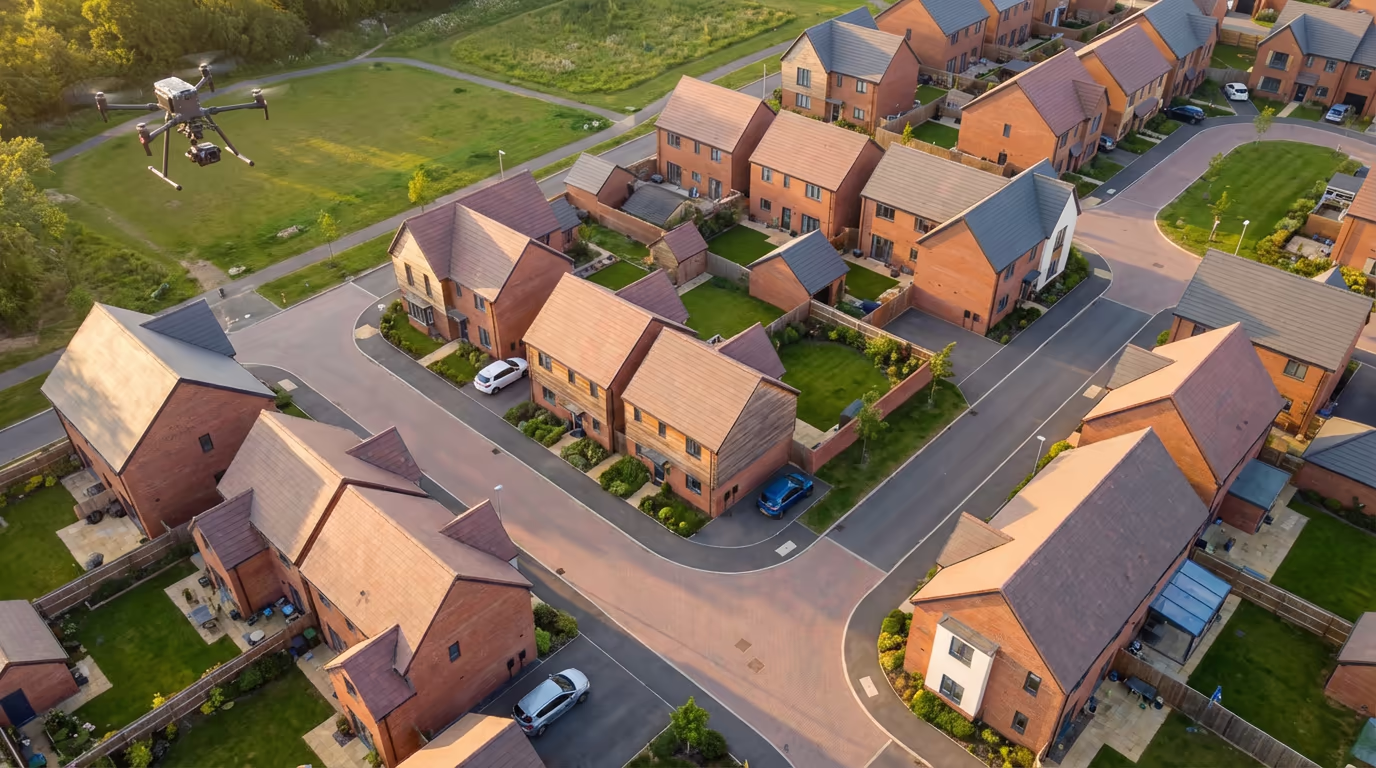
A drone as-built survey captures the precise dimensions, positions, and conditions of completed construction works using aerial photogrammetry and survey-grade GPS technology. It creates an accurate record of what was actually built, rather than what was planned, providing essential documentation for handover, compliance, and future reference.
At Drone Survey Services, we deploy the latest UAV technology to capture comprehensive as-built data quickly and accurately. Our surveys document everything from building positions and levels to infrastructure layouts and landscaping, delivering the precise measurements needed to verify construction against approved designs.

James Leslie
Owner, Engineer & Drone Pilot
"Got questions? Call me directly - I'm happy to talk through your project."
Call NowAccurate As-Built Records,Delivered Fast
What You'll Receive
- Georeferenced orthomosaic
- As-built CAD drawings
- BIM comparison reports
- Survey-grade accuracy (±2-3cm)
Delivered in 3-5 working days
Why Choose Us
- CAA approved & fully insured
- Construction survey specialists
- Latest DJI & RTK technology
- UK-wide coverage
Trusted by contractors, developers & local authorities across the UK.
Trusted by leading organisations
How Much Does a Drone As-Built Survey Cost?
Pricing depends on your project scope. Here's a guide to help you budget:
| Project Size | Guide Price |
|---|---|
| SmallSingle building | £500+ |
| MediumSmall development | £900+ |
| LargeMedium development | £1,500+ |
| Major DevelopmentLarge scheme | £2,500+ |
| Multi-PhasePhased projects | POA |
*Guide prices include standard deliverables. Final quote based on site complexity, access, and specific requirements.
What affects your quote?
- Project size & complexity
- Required deliverables
- BIM comparison needs
- Turnaround time
Our drone-based approach typically saves 50-70% compared to traditional ground surveys while delivering faster turnaround. Contact us with your project details and we'll provide a tailored quote within 24 hours.
Ready to get a quote for your project?
Free, no-obligation quotes within 24 hours
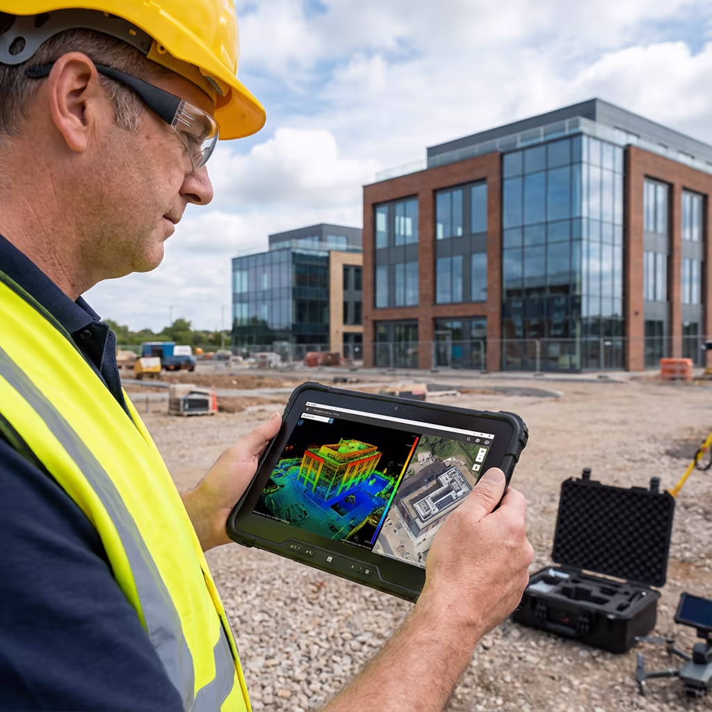
What Is the Difference Between Drone As-Built Survey and Traditional Methods?
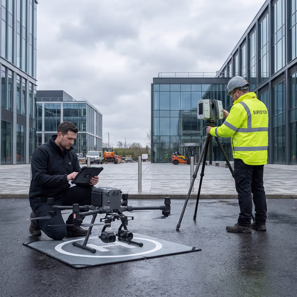
Traditional as-built surveys rely on ground-based total stations and manual measurements, requiring surveyors to physically access every point on site. This approach is time-consuming, labour-intensive, and often requires scaffolding or access equipment for elevated features.
Drone as-built surveys capture thousands of measurements in a single flight, creating comprehensive 3D models and orthomosaics that document the entire site from above. This aerial perspective ensures nothing is missed, while RTK-enabled GPS delivers survey-grade accuracy without ground control points for most applications.
When to Choose Each Approach
Choose Drone As-Built
Speed & coverage
Choose Traditional
Internal & detail work
Not sure which approach suits your project?
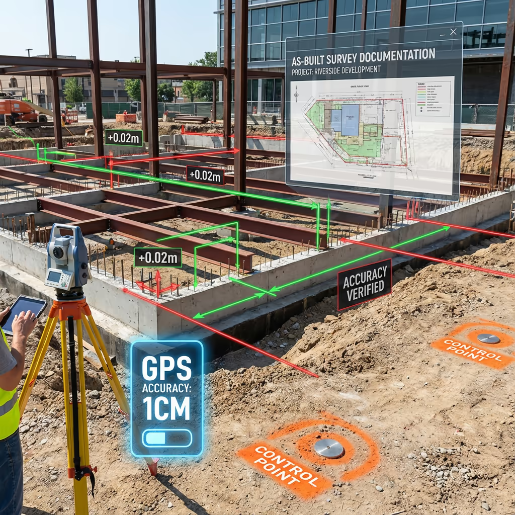
What Accuracy Can a Drone As-Built Survey Achieve?
Our drone as-built surveys routinely achieve absolute accuracy of ±2-3cm horizontally and ±3-5cm vertically when using ground control points. For most construction verification purposes, this level of precision exceeds requirements and matches or beats traditional survey methods.
We use RTK-enabled drones with real-time GPS correction to ensure precise positioning throughout data capture. For projects requiring the highest accuracy, we establish ground control networks using survey-grade GNSS receivers. The result is reliable, repeatable data that stands up to scrutiny from clients, contractors, and planning authorities.
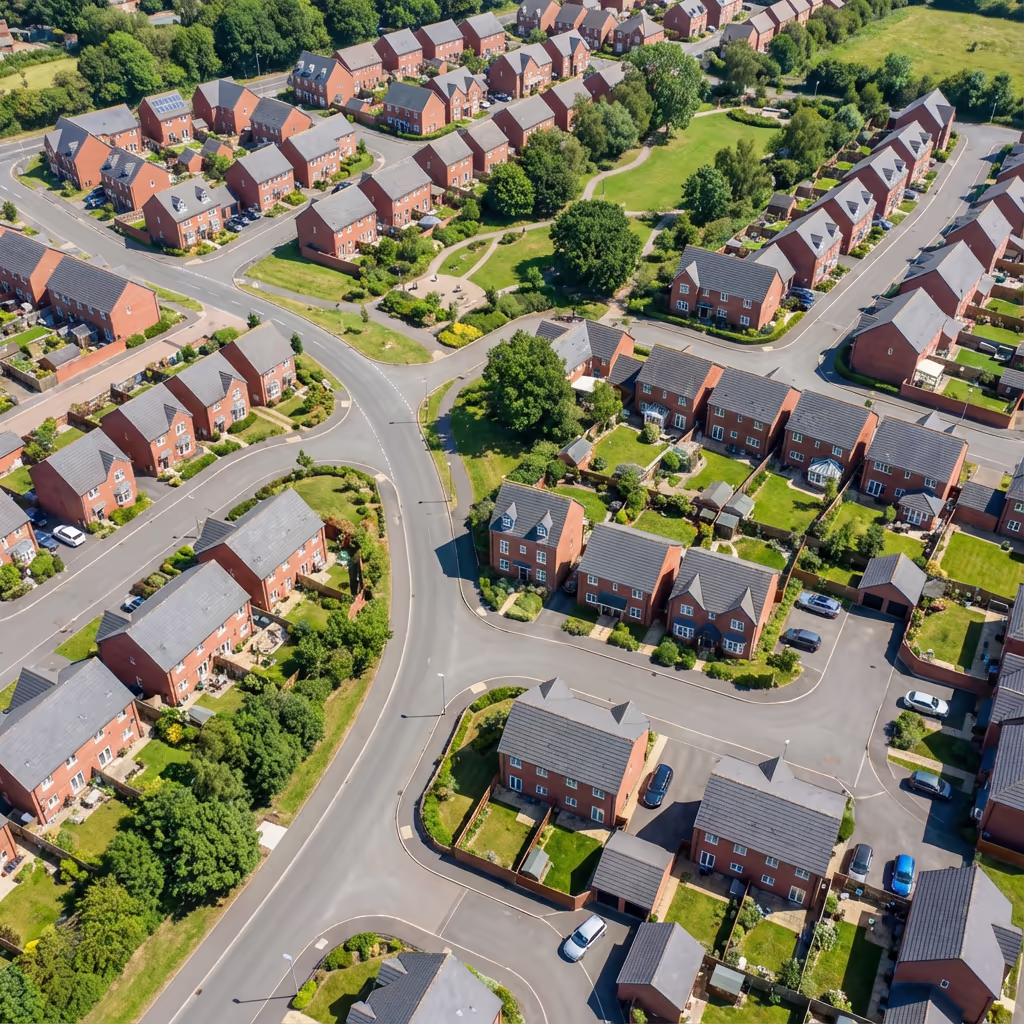
What Are the Applications of Drone As-Built Survey?
Drone as-built surveys serve critical functions across the construction lifecycle. Here are the key applications where our clients see the greatest value:
Project Handover
Comprehensive documentation of completed works for client acceptance, featuring accurate records of building positions, levels, and external features.
Planning Compliance
Evidence for planning condition discharge, demonstrating that construction matches approved drawings and specifications.
BIM Verification
Comparing completed construction against BIM models to identify deviations and update digital twins with as-built reality.
Dispute Resolution
Independent survey evidence for construction disputes, boundary disagreements, or defect claims requiring accurate measurements.
Asset Management
Creating accurate records for facilities management, maintenance planning, and future development considerations.
Infrastructure Recording
Documenting completed roads, drainage, utilities, and landscaping for adoption by local authorities or management companies.
Have a project that needs as-built documentation?

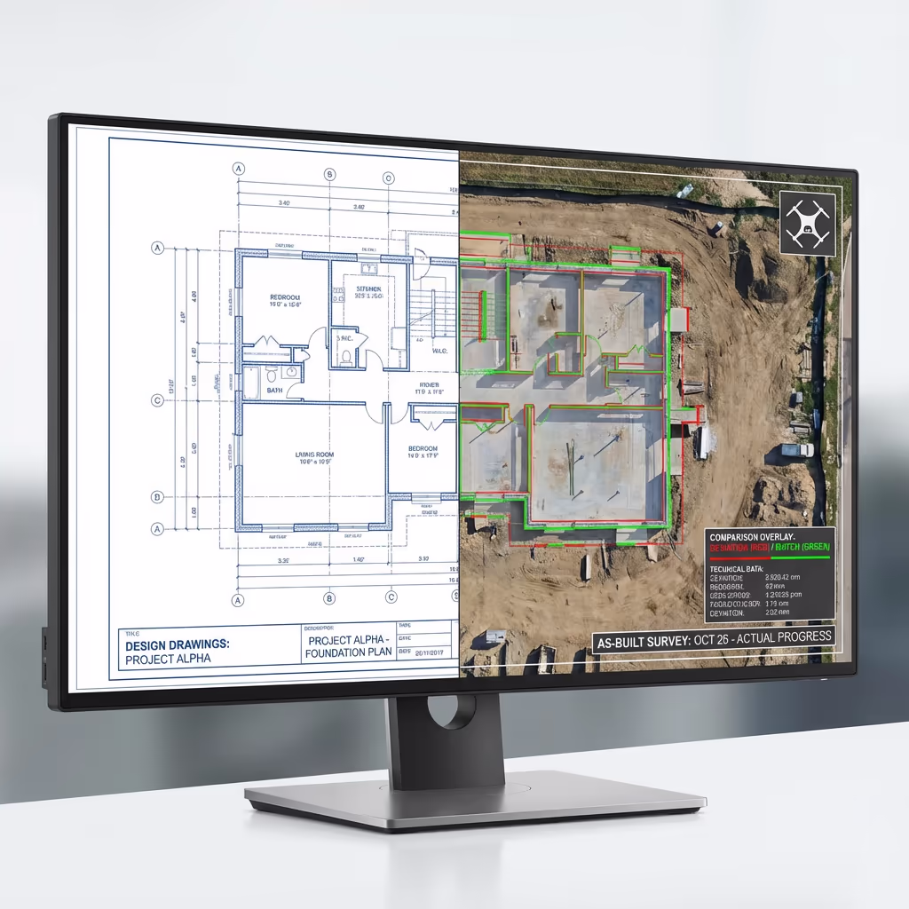
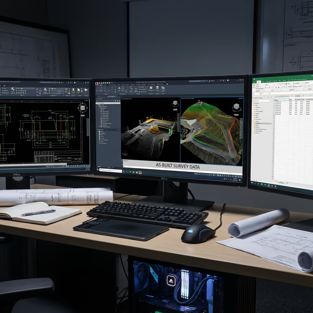
Can Drone As-Built Surveys Compare to BIM Models?
Absolutely—this is one of the most powerful applications of drone as-built surveying. We create precise 3D point clouds and models from aerial data that can be directly compared against your design BIM, identifying deviations between what was planned and what was built.
Our comparison reports highlight discrepancies using colour-coded deviation maps, making it immediately clear where construction differs from design intent. Whether you're verifying contractor performance, updating as-built models, or preparing for handover, this comparison capability provides objective evidence of construction accuracy.
BIM Comparison Deliverables
- Colour-coded deviation maps showing construction vs design
- Quantified deviation reports with measurements
- Updated as-built BIM models
- Clash detection between as-built and design elements
- Point cloud registration to design coordinates
What Deliverables Do You Get From a Drone As-Built Survey?
We tailor deliverables to your project requirements, but our standard as-built survey outputs include:
As-Built Orthomosaic
High-resolution georeferenced aerial imagery showing the completed development in precise detail, suitable for measurements and annotations.
BIM Comparison Reports
Detailed deviation analysis comparing as-built data to design models, with colour-coded visualisations and measurement reports.
Deviation Reports
Quantified reports highlighting where construction differs from approved plans, with precise measurements of any discrepancies.
CAD Files (DWG/DXF)
Scaled CAD drawings in your preferred format, ready for integration with existing project documentation and design software.
3D Models
Photorealistic 3D models and point clouds for visualisation, measurement, and integration with BIM workflows.
Completion Records
Comprehensive documentation packages for project handover, planning discharge, and long-term asset records.
Need specific deliverables for your project?
How Long Does a Drone As-Built Survey Take?
On-site data capture is remarkably efficient. A typical housing development can be surveyed in just 1-2 hours of flight time, plus setup and ground control establishment. Larger sites may require half a day to a full day depending on complexity.
Processing and delivery depends on project complexity and your required outputs. Standard deliverables are typically ready within 3-5 working days. For urgent handover deadlines, we offer expedited processing with 24-48 hour turnaround available at additional cost.
| Phase | Duration |
|---|---|
| Planning & Booking | 1-2 days |
| On-Site Data Capture | 2-4 hours |
| Processing | 1-2 days |
| BIM Comparison (if req) | 1-2 days |
| Deliverable Generation | 1 day |
| Total (Standard) | 3-5 working days |
Express Processing Available
Need it for handover? 24-48 hour turnaround available for urgent projects.

How Do I Choose a Drone As-Built Survey Provider?
Not all drone survey services are equal. When evaluating providers for as-built work, we recommend checking these key factors:
- CAA authorisation – Ensure they hold valid GVC or legacy PfCO permissions for commercial operations
- Construction experience – As-built surveys require understanding of construction workflows and client needs
- BIM capability – Can they compare to your design models and deliver deviation reports?
- Professional insurance – Public liability and professional indemnity cover appropriate to construction sites
- Relevant case studies – Request examples of similar construction projects they've documented
At Drone Survey Services, we tick every box. We're CAA approved, fully insured, and have delivered as-built surveys for residential developments, commercial projects, and infrastructure schemes throughout the UK.
Ready to work with a trusted as-built survey provider?
Is Drone As-Built Survey Cheaper Than Traditional Methods?
In most scenarios, significantly cheaper. Traditional ground-based as-built surveys require surveyors to physically measure every element of completed construction, often needing scaffolding or access equipment for elevated features. This is time-consuming and labour-intensive.
Our drone approach captures equivalent or better data in a fraction of the time. A development that might take a ground team several days can be surveyed in hours. The cost savings typically range from 50-70% compared to traditional methods, while delivering faster turnaround and comprehensive coverage. For large or complex sites, the economics become even more compelling.
Ready to Discuss Your As-Built Project?
Expert advice • Tailored pricing • Response within 2 hours
James Leslie
Owner, Engineer & Drone Pilot
With extensive experience in surveying and construction, James personally oversees every as-built project to ensure accuracy and professional delivery.
TLDR: Drone As-Built Surveys Explained
As-Built Deliverables
- As-built orthomosaic
- BIM comparison reports
- Deviation reports
- CAD files (DWG/DXF)
- 3D models & point clouds
- Completion records
Discuss Your Project
Get expert advice and tailored pricing.
Enterprise Equipment
Survey-Grade Drone Fleet
We don't use consumer mini drones like other providers. Our fleet consists of industrial, survey-grade aircraft purpose-built for capturing detailed, accurate datasets.

AgEagle eBee X
Professional fixed-wing for rapid terrain coverage

DJI Matrice 400
Engineered for excellence, designed for versatility

WingtraOne GEN II
Best-in-class surveying efficiency for large projects

DJI Matrice 350 RTK
Professional multi-payload platform for precision surveying

DJI Mavic 4E
Portable surveying powerhouse with RTK precision
DJI Matrice 300 RTK
Industry-leading inspection and mapping platform

DJI Matrice 4E
Precision survey drone with oblique capture
1 of 7
← Swipe to explore fleet →
Sensor Technology
Specialised Sensors for All Aerial Surveys
Our aircraft carry professional-grade sensors matched to your project requirements, from high-resolution photogrammetry to terrain-penetrating LiDAR.
LiDAR Sensors
Penetrate vegetation and capture precise terrain data with laser scanning technology.
Applications
- Forestry & vegetation mapping
- Terrain modelling under canopy
- Flood risk assessment
- Archaeological surveys
- Power line corridor mapping
Thermal Imaging
Detect heat signatures for building diagnostics, energy audits, and industrial inspections.
Applications
- Building thermal surveys
- Solar panel inspections
- Electrical fault detection
- Search and rescue
- Livestock monitoring
RGB & Photogrammetry
High-resolution imagery for detailed 3D models, orthomosaics, and visual inspections.
Applications
- Topographic surveys
- 3D model generation
- Progress monitoring
- Asset inspection
- Marketing photography
Need a specific sensor or payload?
Client Testimonials
Why Clients Rate Our Drone Survey Service 5 Stars
Don't just take our word for it. Here's what industry professionals say about working with us.
“By far the best drone surveying company I've used. Responsive, helpful and report quality is spot on. Extremely diligent in highlighting defects outside of scope. 10+ projects completed and never disappointed.”
Mark Reynolds
Building Surveyor
“DSS's drone roof survey was brilliant. James showed me everything wrong with my roof in about 30 minutes. Quick, professional and easy to understand.”
Helen Parker
Homeowner
“Fantastic company to do business with. Been working with the DSS team since 2021 and it's been an absolute pleasure. Highly recommended.”
Robert Hughes
Property Developer