Surveying & Mapping
Drone Elevation Survey Services
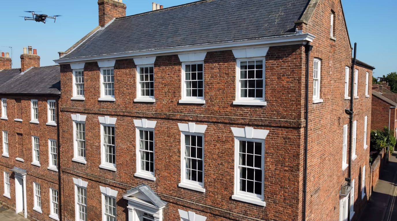
Capture detailed building facades and elevations with precision drone technology. Orthorectified imagery and accurate measurements without scaffolding or access equipment.
Response within 2 hours • Or call 020 4634 0456
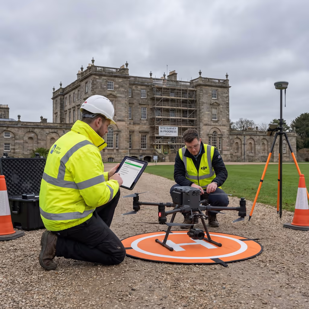
What Is a Drone Elevation Survey?
A drone elevation survey captures detailed imagery of building facades and vertical surfaces using our professional UAVs. Unlike ground-based photography, our drones fly at precise distances parallel to each face of a building, capturing high-resolution images that we process into orthorectified elevation drawings.
At Drone Survey Services, we use advanced photogrammetry techniques to transform these images into scale-accurate facade records. The resulting elevation drawings show true dimensions—you can measure directly from them with millimetre precision. This makes drone elevation surveys invaluable for architects, heritage specialists, and anyone needing detailed building records without expensive scaffolding.

James Leslie
Owner, Engineer & Drone Pilot
"Got questions? Call me directly - I'm happy to talk through your project."
Call NowSurvey-Grade Elevation Data,No Scaffolding Required
What You'll Receive
- Orthorectified facade images
- Scaled elevation drawings
- 3D facade models
- CAD-ready files (DXF/DWG)
Delivered in 3-5 working days
Why Choose Us
- CAA approved & fully insured
- Specialist facade processing
- Latest DJI technology
- UK-wide coverage
Trusted by architects, heritage consultants & property professionals across the UK.
Trusted by leading organisations
How Much Does a Drone Elevation Survey Cost?
Pricing depends on building size and complexity. Here's a guide to help you budget:
| Project Type | Guide Price |
|---|---|
| Single Facade1 elevation | £350+ |
| Small Building2-4 facades | £500+ |
| Medium BuildingMulti-storey | £800+ |
| Large/ComplexHeritage/complex form | £1,200+ |
| Multi-BuildingEstate/campus | POA |
*Guide prices include standard deliverables. Final quote based on building height, access, and specific requirements.
What affects your quote?
- Building height & complexity
- Number of facades
- Access restrictions
- Required deliverables
Our drone-based approach typically saves 60-80% compared to traditional scaffolding surveys. Contact us with your project details and we'll provide a tailored quote within 24 hours.
Ready to get a quote for your project?
Free, no-obligation quotes within 24 hours

What Is the Difference Between Drone Elevation Survey and Traditional Methods?
Traditional building elevation surveys typically require scaffolding, cherry pickers, or rope access to capture facade imagery at height. This means significant setup costs, site disruption, and health and safety considerations. A single facade on a three-storey building might need £2,000+ of scaffolding hire before any survey work begins.
Drone elevation surveys eliminate these access costs entirely. Our drones capture imagery from any height and angle without touching the building, working around obstacles and reaching areas that would be impractical or dangerous for traditional methods. We complete most elevation surveys in a single day with minimal site disruption.
When to Choose Each Method
Drone Elevation Survey
Fast & cost-effective
Traditional Methods
Scaffolding/access required
Not sure which method suits your project?
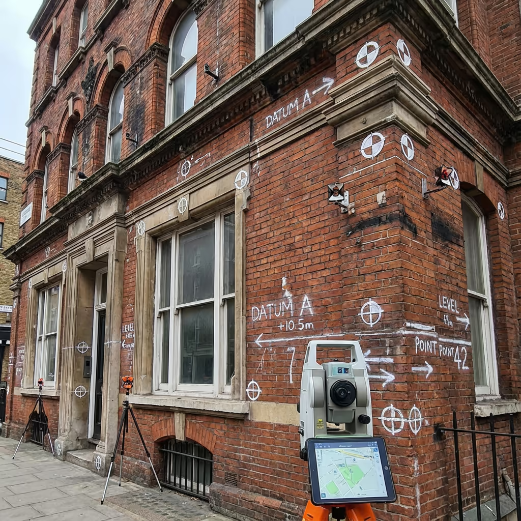
What Accuracy Can a Drone Elevation Survey Achieve?
Our drone elevation surveys routinely achieve accuracy of ±5-10mm across the facade surface when using ground control points. This level of precision exceeds the requirements for most architectural, heritage, and planning applications.
We achieve this through careful flight planning at optimal distances from the building, high-overlap image capture, and rigorous photogrammetric processing. For projects requiring the highest accuracy, we establish survey control networks and validate measurements against known references. The resulting orthorectified images are true-to-scale—you can measure window dimensions, crack widths, or architectural details directly from the deliverables.
What Are the Applications of Drone Elevation Survey?
Drone elevation surveys serve a wide range of industries and purposes. Here are the key applications where our clients see the greatest value:
Heritage & Conservation
Recording listed buildings, condition surveys for conservation plans, and detailed facade documentation for heritage applications.
Architecture & Design
As-built facade records for refurbishment projects, extension designs, and building information modelling (BIM) input.
Property & Asset Management
Building condition assessments, facade inspection records, and portfolio documentation for estates and facilities teams.
Planning & Development
Accurate elevation drawings for planning applications, impact assessments, and development proposals.
Insurance & Claims
Pre and post-loss documentation, defect surveys, and detailed records for dispute resolution and claims support.
Facade Maintenance
Identifying repair requirements, scheduling maintenance works, and tracking building condition over time.
Have a building that needs elevation survey?
Can Drone Elevation Surveys Capture All Building Faces?
In most cases, yes. Our drones can capture facades that face any direction, including north-facing elevations that rarely receive direct sunlight. We plan flights to optimise lighting conditions across all faces, often capturing different elevations at different times of day for consistent image quality.
However, some situations present challenges. Buildings very close to boundaries may have restricted airspace for drone operations. Internal courtyards or light wells with limited overhead clearance can be difficult to access. In these cases, we assess each facade individually and advise on the best approach—sometimes combining drone capture with ground-based photography for complete coverage. We'll always be upfront about any limitations during the quotation process.

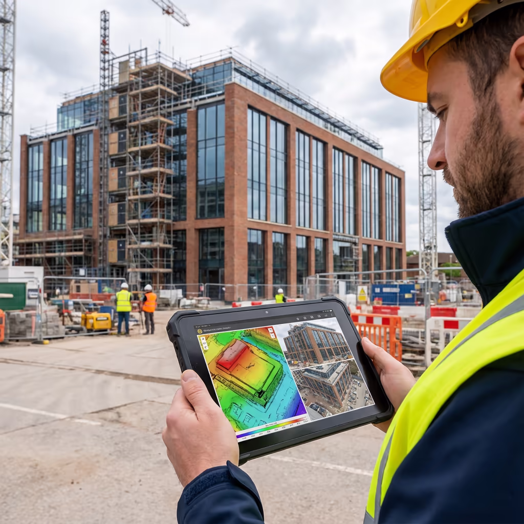
What Deliverables Do You Get From a Drone Elevation Survey?
We tailor deliverables to your project requirements, but our standard drone elevation survey outputs include:
Orthorectified Facade Images
True-to-scale photographic images of each facade, corrected for perspective distortion. Measure directly from the image in any software.
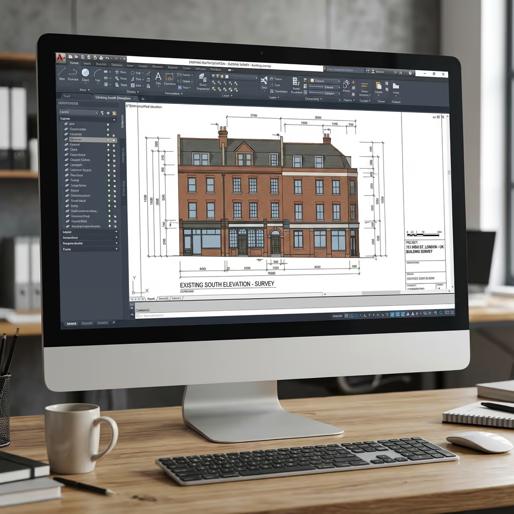
Elevation Drawings
Professional architectural elevation drawings with key dimensions annotated. Supplied as PDF and CAD formats.
3D Facade Models
Textured 3D mesh models of building facades for visualisation, BIM integration, and detailed analysis.
CAD Files (DXF/DWG)
Ready-to-use vector files compatible with AutoCAD, Revit, and other design software. Scale-accurate and georeferenced.
Measurement Data
Comprehensive measurement reports including overall dimensions, window schedules, and feature locations as required.
Need specific deliverables for your project?
How Long Does a Drone Elevation Survey Take?
On-site data capture is typically completed in a single visit. A small building with four facades takes 1-2 hours of flight time. Larger or more complex buildings may require half a day. We work efficiently to minimise disruption to building occupants and neighbours.
Processing and delivery depends on project complexity. Standard deliverables for a typical building are ready within 3-5 working days. Complex heritage projects with detailed annotation requirements may take 5-7 days. For urgent projects, we offer expedited processing—ask about fast-track options when you get in touch.
| Phase | Duration |
|---|---|
| Planning & Permissions | 1-2 days |
| On-Site Data Capture | 2-4 hours |
| Image Processing | 1-2 days |
| Deliverable Production | 1-2 days |
| Total (Standard) | 3-5 working days |
Express Processing Available
Need it faster? 24-48 hour turnaround available for urgent projects.

How Do I Choose a Drone Elevation Survey Provider?
Not all drone survey providers have the expertise for elevation work. When evaluating providers, we recommend checking these key factors:
- CAA authorisation – Ensure they hold valid GVC or legacy PfCO permissions for commercial operations
- Professional insurance – Public liability and professional indemnity cover appropriate to building survey work
- Facade survey experience – Elevation surveys require specialist knowledge in vertical photogrammetry
- CAD capability – Ask about their processing workflow and deliverable formats
- Relevant case studies – Request examples of similar building surveys they've completed
At Drone Survey Services, we tick every box. We're CAA approved, fully insured, and have delivered elevation surveys for heritage buildings, commercial properties, and residential developments throughout the UK.
Ready to work with a trusted elevation survey provider?
Is Drone Elevation Survey Cheaper Than Traditional Methods?
In almost every case, significantly cheaper. Traditional elevation surveys require physical access to the building face—typically via scaffolding, cherry picker, or rope access. For a three-storey building, scaffolding alone can cost £2,000-5,000 before any survey work begins. Add the surveyor's time, traffic management, and building occupation disruption, and costs escalate rapidly.
Our drone elevation surveys eliminate these access costs entirely. We capture the same quality imagery—often better—without touching the building. The total cost typically represents a 60-80% saving compared to traditional scaffolding-based surveys, while delivering faster turnaround and causing minimal site disruption. For multi-storey or difficult-access buildings, the savings are even more significant.
Ready to Discuss Your Elevation Survey Project?
Expert advice • Tailored pricing • Response within 2 hours
James Leslie
Owner, Engineer & Drone Pilot
With extensive experience in surveying and UAV operations, James personally oversees every elevation survey to ensure accurate, professional deliverables.
TLDR: Drone Elevation Surveys Explained
Elevation Survey Deliverables
- Orthorectified facade images
- Elevation drawings (PDF/CAD)
- 3D facade models
- CAD files (DXF/DWG)
- Measurement data
- High-res source imagery
Discuss Your Project
Get expert advice and tailored pricing.
Enterprise Equipment
Survey-Grade Drone Fleet
We don't use consumer mini drones like other providers. Our fleet consists of industrial, survey-grade aircraft purpose-built for capturing detailed, accurate datasets.

AgEagle eBee X
Professional fixed-wing for rapid terrain coverage

DJI Matrice 400
Engineered for excellence, designed for versatility

WingtraOne GEN II
Best-in-class surveying efficiency for large projects

DJI Matrice 350 RTK
Professional multi-payload platform for precision surveying

DJI Mavic 4E
Portable surveying powerhouse with RTK precision
DJI Matrice 300 RTK
Industry-leading inspection and mapping platform

DJI Matrice 4E
Precision survey drone with oblique capture
1 of 7
← Swipe to explore fleet →
Sensor Technology
Specialised Sensors for All Aerial Surveys
Our aircraft carry professional-grade sensors matched to your project requirements, from high-resolution photogrammetry to terrain-penetrating LiDAR.
LiDAR Sensors
Penetrate vegetation and capture precise terrain data with laser scanning technology.
Applications
- Forestry & vegetation mapping
- Terrain modelling under canopy
- Flood risk assessment
- Archaeological surveys
- Power line corridor mapping
Thermal Imaging
Detect heat signatures for building diagnostics, energy audits, and industrial inspections.
Applications
- Building thermal surveys
- Solar panel inspections
- Electrical fault detection
- Search and rescue
- Livestock monitoring
RGB & Photogrammetry
High-resolution imagery for detailed 3D models, orthomosaics, and visual inspections.
Applications
- Topographic surveys
- 3D model generation
- Progress monitoring
- Asset inspection
- Marketing photography
Need a specific sensor or payload?
Client Testimonials
Why Clients Rate Our Drone Survey Service 5 Stars
Don't just take our word for it. Here's what industry professionals say about working with us.
“By far the best drone surveying company I've used. Responsive, helpful and report quality is spot on. Extremely diligent in highlighting defects outside of scope. 10+ projects completed and never disappointed.”
Mark Reynolds
Building Surveyor
“DSS's drone roof survey was brilliant. James showed me everything wrong with my roof in about 30 minutes. Quick, professional and easy to understand.”
Helen Parker
Homeowner
“Fantastic company to do business with. Been working with the DSS team since 2021 and it's been an absolute pleasure. Highly recommended.”
Robert Hughes
Property Developer