Waste Management Surveying
Drone Landfill Survey Services
Precision aerial surveys for landfill volume calculations, void space analysis, and regulatory compliance monitoring across UK waste management sites.
Response within 2 hours • Or call 020 4634 0456
What Is a Drone Landfill Survey?
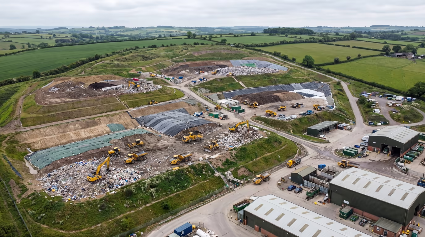
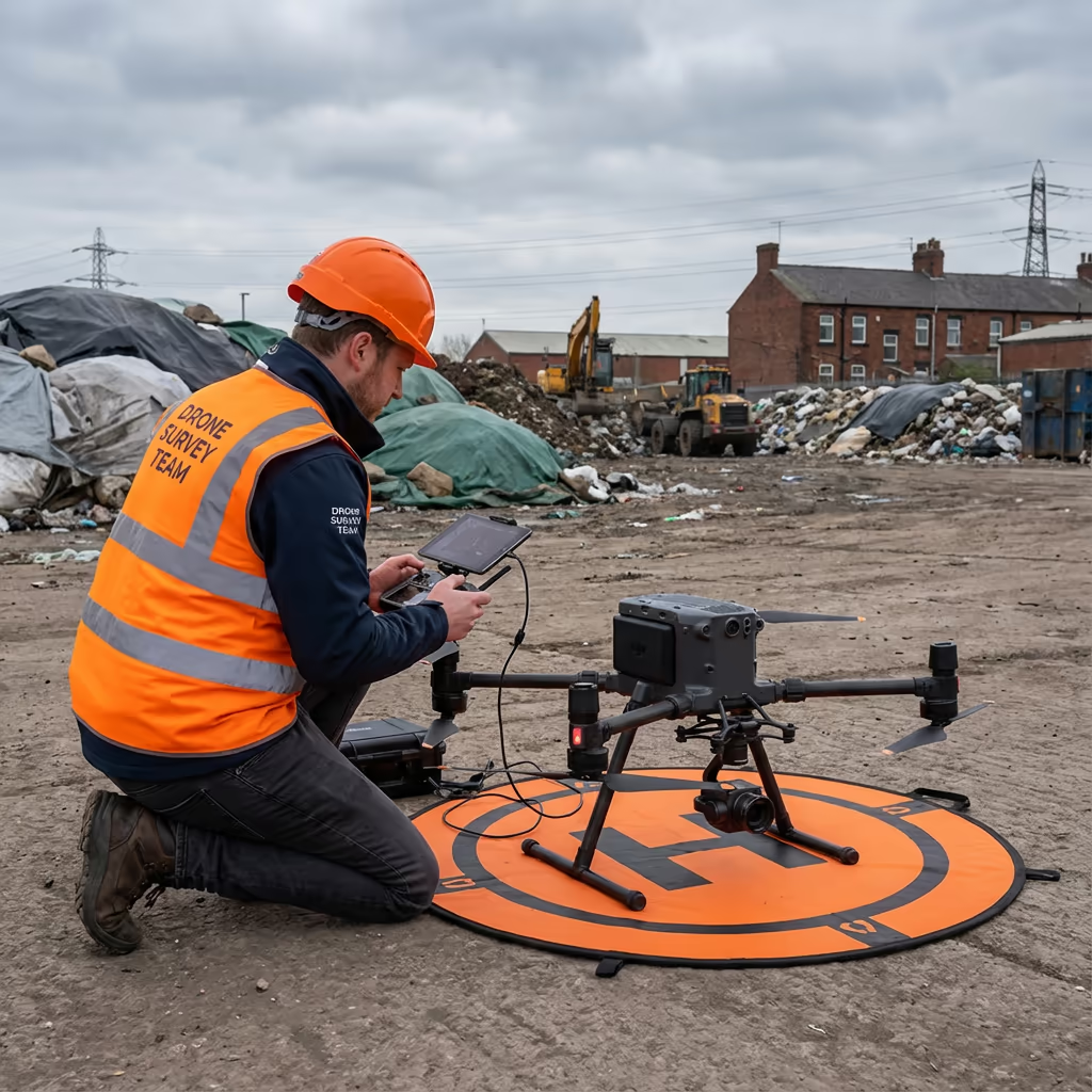
A drone landfill survey uses advanced UAV technology to capture precise aerial data of waste management sites, enabling accurate volume calculations, capacity monitoring, and regulatory compliance reporting. Our drones collect thousands of data points across your site in minutes, creating detailed 3D models that reveal the true shape and volume of your landfill cells.
At Drone Survey Services, we specialise in landfill surveying for waste management operators, environmental consultants, and local authorities across the UK. Our surveys provide the accurate, defensible data you need for environmental permits, void space calculations, and operational planning—all captured safely without disrupting active tipping operations.

James Leslie
Owner, Engineer & Drone Pilot
"Got questions? Call me directly - I'm happy to talk through your project."
Call NowAccurate Landfill Volume Data,Delivered Fast
What You'll Receive
- Accurate volume calculations
- Void space & capacity analysis
- Progress tracking reports
- Survey-grade accuracy (±2-5cm)
Delivered in 5-7 working days
Why Choose Us
- CAA approved & fully insured
- Landfill survey specialists
- Latest DJI & RTK technology
- UK-wide coverage
Trusted by waste management operators and environmental consultants across the UK.
Trusted by leading organisations
How Much Does a Drone Landfill Survey Cost?
Pricing depends on your site size and requirements. Here's a guide to help you budget:
| Project Size | Guide Price |
|---|---|
| Single Cell1 landfill cell | £600+ |
| Small Site2-5 cells | £1,000+ |
| Medium Site5-15 cells | £1,800+ |
| Large Site15+ cells | £3,000+ |
| Recurring MonthlyOngoing monitoring | POA |
*Guide prices include standard deliverables. Final quote based on site complexity, access, and specific requirements.
What affects your quote?
- Number of cells
- Site complexity
- Required deliverables
- Survey frequency
Our drone-based approach typically saves 50-70% compared to traditional ground surveys of landfill sites. Contact us with your project details and we'll provide a tailored quote within 24 hours.
Ready to get a quote for your landfill survey?
Free, no-obligation quotes within 24 hours
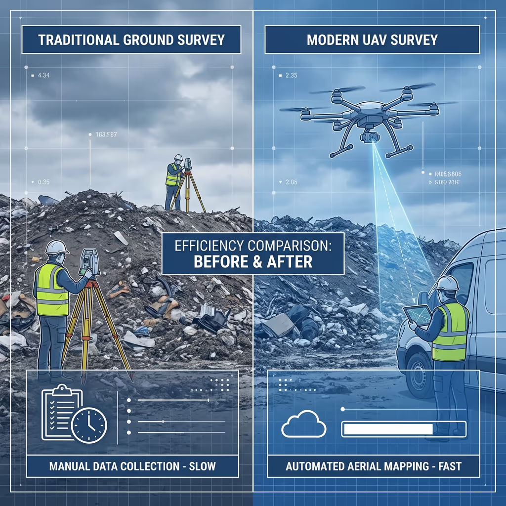
What Is the Difference Between Drone Landfill Survey and Traditional Methods?
Traditional landfill surveys require surveyors to walk across active tipping areas, taking measurements with total stations or GPS equipment. This is slow, expensive, and often dangerous on unstable waste surfaces. Ground teams also struggle to capture detail in areas with active machinery operations.
Drone landfill surveys capture comprehensive data from the air, eliminating safety risks and dramatically reducing survey time. Our UAVs fly autonomous missions over your site, capturing thousands of georeferenced images that we process into accurate 3D models and volume calculations—all without setting foot on the waste surface.
When to Choose Each Method
Choose Drone Survey
Fast, safe & comprehensive
Choose Traditional
Specific detail required
Not sure which approach suits your site?
What Accuracy Can a Drone Landfill Survey Achieve?
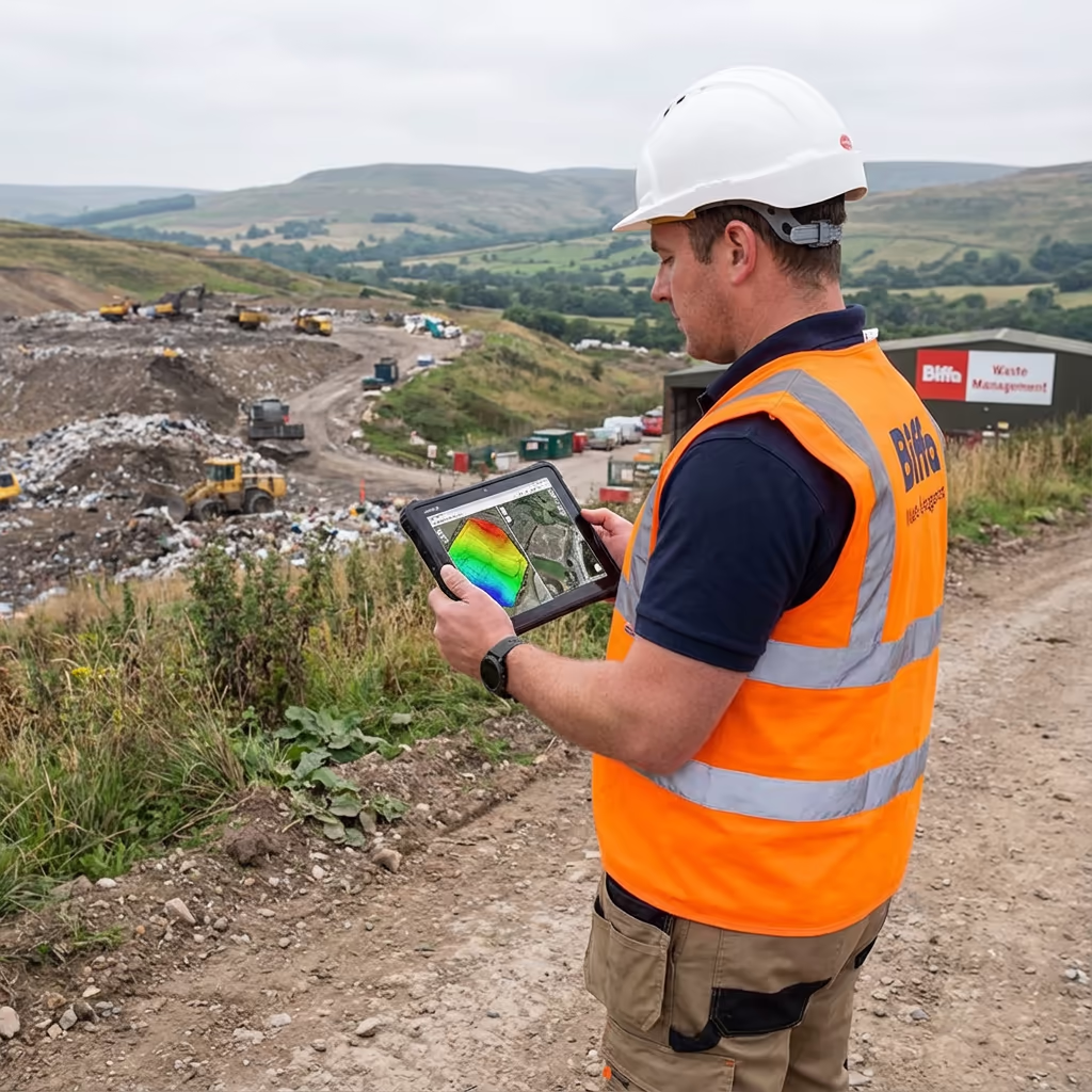
Our drone landfill surveys routinely achieve vertical accuracy of ±2-5cm and horizontal accuracy of ±3-5cm when using ground control points. This precision exceeds the requirements for environmental permit reporting and provides reliable data for void space calculations and capacity planning.
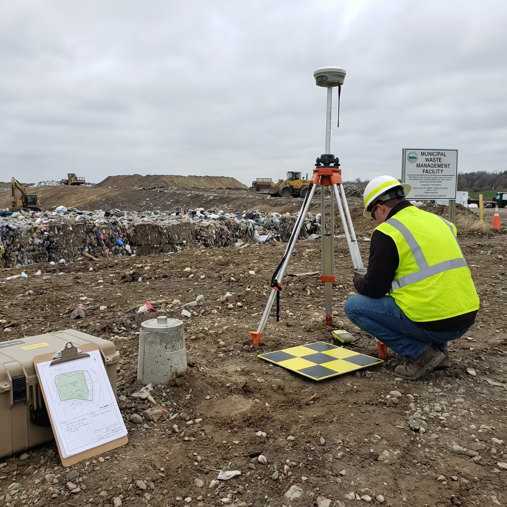
We use RTK-enabled drones with integrated GNSS positioning, supplemented by strategically placed ground control points around your site. This combination ensures consistent accuracy across the entire survey area, regardless of cell activity or terrain variations. The result is volume calculations you can confidently submit to regulators and use for operational decisions.
What Are the Applications of Drone Landfill Survey?
Drone landfill surveys serve waste management operations across the entire site lifecycle. Here are the key applications where our clients see the greatest value:
Volume Measurement
Accurate calculation of waste volumes deposited, tracking fill rates and comparing against permit allowances.
Capacity Monitoring
Ongoing measurement of remaining void space to inform operational planning and permit applications.
Regulatory Compliance
Providing accurate survey data for Environment Agency reporting, permit variations, and compliance documentation.
Progress Tracking
Regular surveys to monitor cell progression, compare against engineering designs, and document construction phases.
Restoration Monitoring
Tracking capping and restoration works, verifying profiles against design specifications and settlement monitoring.
Due Diligence
Independent survey data for site acquisitions, valuations, and verification of reported volumes and remaining capacity.
Have a landfill that needs surveying?
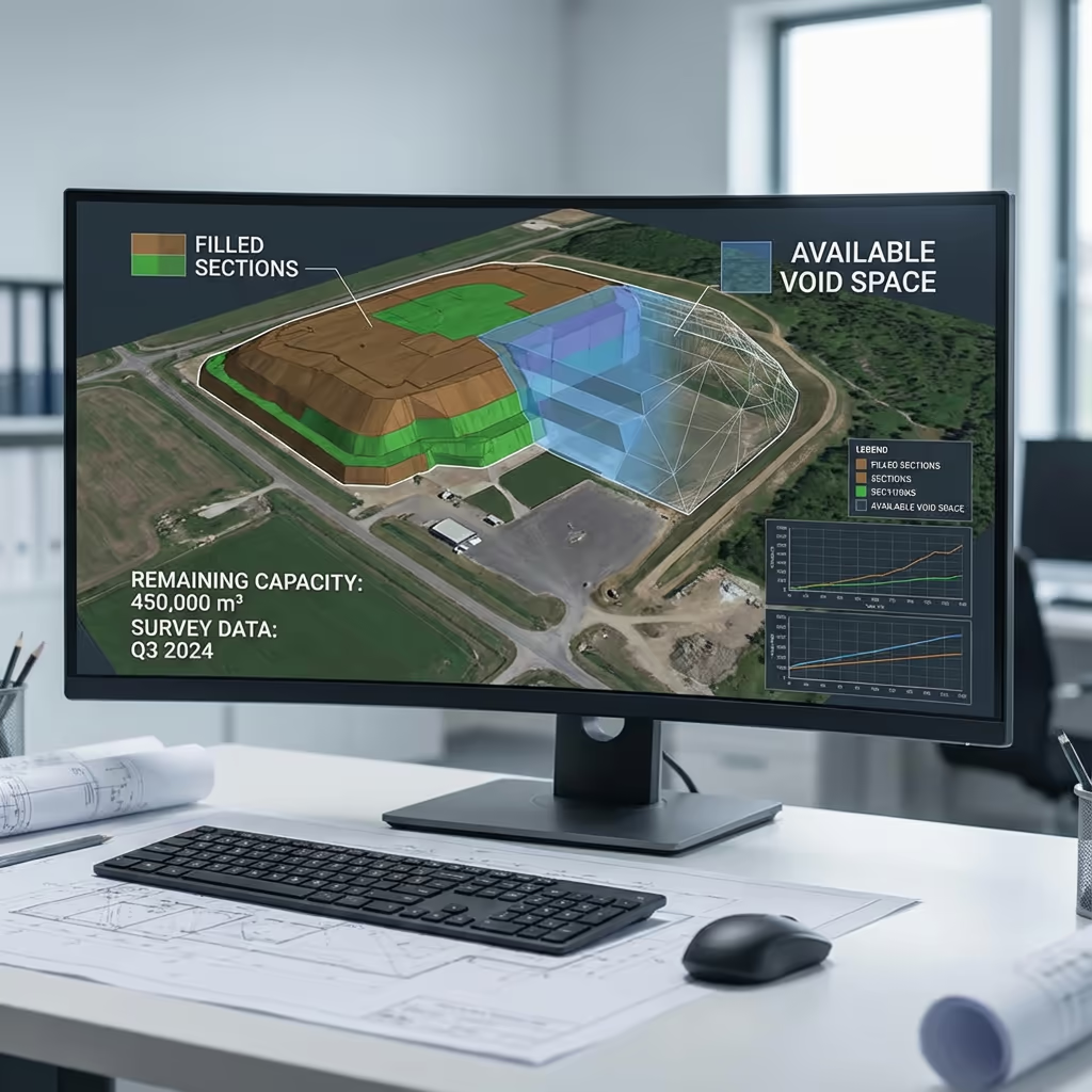
Can Drones Calculate Remaining Landfill Capacity?
Yes—this is one of the most valuable applications of drone landfill surveys. By comparing our accurate 3D surface models against your permitted final contours or engineering designs, we calculate precisely how much void space remains in each cell. This void space analysis is essential for planning tipping operations, forecasting site life, and supporting permit applications.
We can also track how capacity changes over time with regular monitoring surveys. This gives you reliable data for business planning, helps optimise cell utilisation, and provides the documentation regulators require. Our reports clearly present remaining capacity in cubic metres, making it easy to communicate with stakeholders and plan for future developments.

What Deliverables Do You Get From a Drone Landfill Survey?
We tailor deliverables to your specific requirements, but our standard drone landfill survey outputs include:
Volume Calculations
Accurate volume reports showing total waste deposited, changes since previous surveys, and remaining capacity in each cell.
Void Space Analysis
Detailed reports showing remaining permitted capacity, comparison against design profiles, and projected site life calculations.
Progress Tracking Reports
Visual and numerical comparison between survey dates, showing fill rates, settlement, and operational progress over time.
Regulatory Reports
Documentation formatted for Environment Agency submissions, permit compliance, and annual returns.
CAD Files & 3D Models
Digital surface models, contours, and CAD-ready files compatible with AutoCAD, Civil 3D, and other engineering software.
Need specific deliverables for your project?
How Long Does a Drone Landfill Survey Take?
On-site data capture is remarkably fast compared to traditional methods. A typical landfill site with 5-10 cells can be surveyed in 2-4 hours of flight time, plus setup and ground control point establishment. Larger sites may require a full day on site.
Processing and delivery depends on project complexity and your required outputs. Standard deliverables including volume calculations and reports are typically ready within 5-7 working days. For urgent requirements, we offer expedited processing with 48-72 hour turnaround available at additional cost.
| Phase | Duration |
|---|---|
| Planning & Coordination | 1-2 days |
| On-Site Data Capture | ½-1 day |
| Data Processing | 2-3 days |
| Volume Analysis | 1-2 days |
| Deliverable Generation | 1-2 days |
| Total (Standard) | 5-7 working days |
Express Processing Available
Need it faster? 48-72 hour turnaround available for urgent projects.

How Do I Choose a Drone Landfill Survey Provider?
Not all drone survey providers understand the specific requirements of waste management sites. When evaluating providers for your landfill survey, we recommend checking these key factors:
- CAA authorisation – Ensure they hold valid GVC or legacy PfCO permissions for commercial operations
- Landfill experience – Waste sites have unique challenges; look for proven experience in the sector
- Professional insurance – Public liability and professional indemnity cover appropriate to waste site operations
- Volume calculation expertise – Ask about their methodology for volume and void space analysis
- Health & safety compliance – Familiarity with waste site H&S requirements and induction procedures
At Drone Survey Services, we tick every box. We're CAA approved, fully insured, and have delivered landfill surveys for waste management operators and environmental consultants throughout the UK. We understand the regulatory requirements and can deliver data in the formats your permits require.
Ready to work with a trusted landfill survey provider?
Is Drone Landfill Survey Cheaper Than Traditional Methods?
In virtually all cases, yes—significantly. Traditional ground surveys of active landfill sites are slow, expensive, and carry significant health and safety risks. Surveyors working on unstable waste surfaces need extensive safety measures, and the time required to manually capture data across large cells makes costs escalate quickly.
Our drone surveys capture comprehensive, accurate data in a fraction of the time with no personnel on the waste surface. The cost savings typically range from 50-70% compared to traditional methods, while also delivering faster turnaround and more detailed datasets. For sites requiring regular monitoring, the economics become even more favourable with recurring survey packages.
Ready to Discuss Your Landfill Survey Project?
Expert advice • Tailored pricing • Response within 2 hours
James Leslie
Owner, Engineer & Drone Pilot
With extensive experience in surveying and UAV operations, James personally oversees every landfill survey project to ensure accurate volume data and professional delivery.
TLDR: Drone Landfill Surveys Explained
Landfill Survey Deliverables
- Volume calculations
- Void space analysis
- Progress tracking reports
- Regulatory compliance reports
- CAD files (DWG/DXF)
- 3D surface models
Discuss Your Project
Get expert advice and tailored pricing.
Enterprise Equipment
Survey-Grade Drone Fleet
We don't use consumer mini drones like other providers. Our fleet consists of industrial, survey-grade aircraft purpose-built for capturing detailed, accurate datasets.

AgEagle eBee X
Professional fixed-wing for rapid terrain coverage

DJI Matrice 400
Engineered for excellence, designed for versatility

WingtraOne GEN II
Best-in-class surveying efficiency for large projects

DJI Matrice 350 RTK
Professional multi-payload platform for precision surveying

DJI Mavic 4E
Portable surveying powerhouse with RTK precision
DJI Matrice 300 RTK
Industry-leading inspection and mapping platform

DJI Matrice 4E
Precision survey drone with oblique capture
1 of 7
← Swipe to explore fleet →
Sensor Technology
Specialised Sensors for All Aerial Surveys
Our aircraft carry professional-grade sensors matched to your project requirements, from high-resolution photogrammetry to terrain-penetrating LiDAR.
LiDAR Sensors
Penetrate vegetation and capture precise terrain data with laser scanning technology.
Applications
- Forestry & vegetation mapping
- Terrain modelling under canopy
- Flood risk assessment
- Archaeological surveys
- Power line corridor mapping
Thermal Imaging
Detect heat signatures for building diagnostics, energy audits, and industrial inspections.
Applications
- Building thermal surveys
- Solar panel inspections
- Electrical fault detection
- Search and rescue
- Livestock monitoring
RGB & Photogrammetry
High-resolution imagery for detailed 3D models, orthomosaics, and visual inspections.
Applications
- Topographic surveys
- 3D model generation
- Progress monitoring
- Asset inspection
- Marketing photography
Need a specific sensor or payload?
Client Testimonials
Why Clients Rate Our Drone Survey Service 5 Stars
Don't just take our word for it. Here's what industry professionals say about working with us.
“By far the best drone surveying company I've used. Responsive, helpful and report quality is spot on. Extremely diligent in highlighting defects outside of scope. 10+ projects completed and never disappointed.”
Mark Reynolds
Building Surveyor
“DSS's drone roof survey was brilliant. James showed me everything wrong with my roof in about 30 minutes. Quick, professional and easy to understand.”
Helen Parker
Homeowner
“Fantastic company to do business with. Been working with the DSS team since 2021 and it's been an absolute pleasure. Highly recommended.”
Robert Hughes
Property Developer