Solar Asset Management
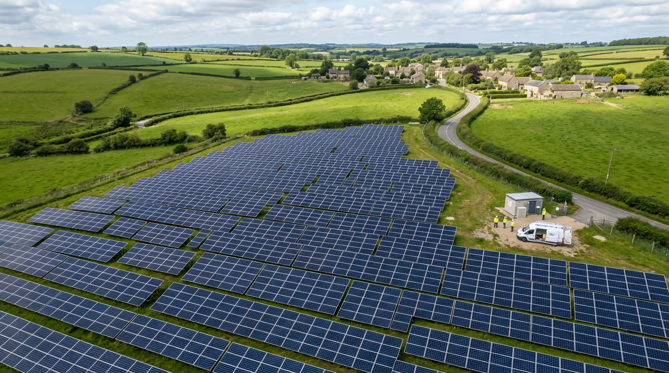
Drone Solar Farm Survey Services
Precision thermal imaging and inspection services for solar farms. Detect faulty panels, optimise performance, and maximise your energy yield.
Response within 2 hours - Or call 020 4634 0456
What Is a Drone Solar Farm Survey?
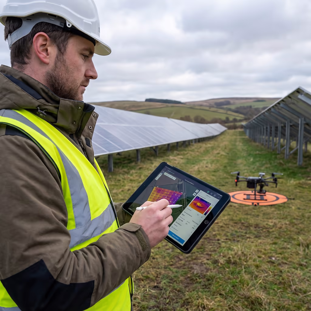
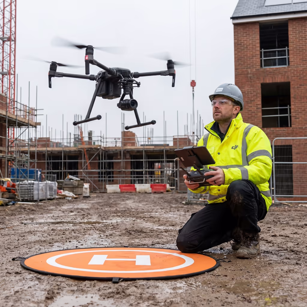
A drone solar farm survey uses thermal imaging cameras mounted on our UAVs to inspect solar panel installations quickly and accurately. Unlike traditional ground-based inspections, our drones can survey entire solar farms in hours rather than days, capturing detailed thermal data that reveals panel defects invisible to the naked eye.
At Drone Survey Services, we combine high-resolution RGB imagery with radiometric thermal sensors capable of detecting temperature variations as small as 0.05 degrees Celsius. This precision allows us to identify hotspots, bypass diodes failures, cell fractures, and soiling issues that reduce your energy output and can cause costly damage if left undetected.

James Leslie
Owner, Engineer & Drone Pilot
"Got questions? Call me directly - I'm happy to talk through your project."
Call NowComprehensive Solar Farm Inspection,Delivered Fast
What You'll Receive
- Thermal imagery of every panel
- Panel defect report with locations
- High-resolution orthomosaic
- Maintenance priority list
Delivered in 5-7 working days
Why Choose Us
- CAA approved & fully insured
- Radiometric thermal cameras
- Latest DJI & sensor technology
- UK-wide coverage
Trusted by solar farm operators, asset managers & O&M providers across the UK.
Trusted by leading organisations
How Much Does a Drone Solar Farm Survey Cost?
Pricing depends on your site capacity and inspection requirements. Here's a guide to help you budget:
| Site Capacity | Guide Price |
|---|---|
| SmallUnder 5MW | £800+ |
| Medium5-20MW | £1,500+ |
| Large20-50MW | £2,500+ |
| Utility Scale50+ MW | POA |
| Recurring InspectionAnnual contract | POA |
*Guide prices include standard deliverables. Final quote based on site layout, access, and specific requirements.
What affects your quote?
- Site capacity (MW)
- Panel configuration
- Turnaround time
- Report detail level
Our drone-based approach typically saves 60-80% compared to manual panel-by-panel inspection. Contact us with your site details and we'll provide a tailored quote within 24 hours.
Ready to get a quote for your solar farm?
Free, no-obligation quotes within 24 hours
What Is the Difference Between Drone Solar Farm Survey and Manual Inspection?
Traditional manual inspection requires technicians to physically access each panel, checking for visible damage and using handheld thermal cameras. This approach is slow, labour-intensive, and can miss defects that aren't visible at panel level.
Our drone solar farm survey captures thermal and visual data from an optimal aerial position, inspecting thousands of panels per hour. The consistent viewing angle and automated flight paths ensure no panel is missed, while our calibrated thermal sensors detect anomalies that handheld devices simply cannot match in terms of coverage and consistency.
Comparing Inspection Methods
Drone Solar Farm Survey
Fast & comprehensive
Manual Inspection
Traditional approach
Not sure which approach suits your site?

What Accuracy Can a Drone Solar Farm Survey Achieve?
Our radiometric thermal cameras achieve temperature measurement accuracy of better than ±2 degrees Celsius, with thermal sensitivity detecting variations as small as 0.05 degrees. This precision allows us to identify hotspots and anomalies that indicate cell damage, bypass diode failures, or connection issues.
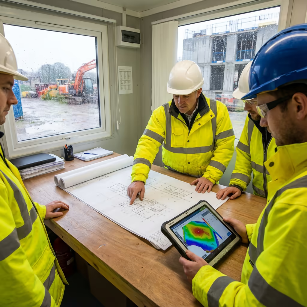
Geospatial accuracy is equally important for locating defects. Using RTK-enabled drones, we position each thermal anomaly to within centimetres, enabling your maintenance team to locate faulty panels quickly. Every defect is mapped with precise GPS coordinates and cross-referenced to your panel layout, ensuring efficient remediation.
What Are the Applications of Drone Solar Farm Survey?
Drone solar farm surveys support the entire lifecycle of solar assets, from pre-acquisition due diligence to ongoing O&M programmes. Here are the key applications:
Asset Acquisition
Independent condition assessment for investors and acquirers. Identify defects and warranty claims before purchase completion.
Performance Optimisation
Identify underperforming panels dragging down string or inverter performance. Prioritise maintenance for maximum yield improvement.
Warranty Compliance
Document panel defects for manufacturer warranty claims. Our reports provide the evidence needed for successful claims.
O&M Contract Handover
Baseline condition surveys when changing O&M providers. Clear documentation of existing defects and maintenance backlog.
Insurance Documentation
Post-event damage assessment following storms, hail, or vandalism. Evidence for insurance claims with georeferenced defect mapping.
Regulatory Compliance
Support for periodic inspection requirements under subsidy schemes. Documented evidence of ongoing asset maintenance.
Ready to inspect your solar farm?

Can Drones Detect Faulty Solar Panels?
Yes - thermal imaging is exceptionally effective at detecting a wide range of solar panel defects. When panels have faults, they generate excess heat that shows clearly on thermal imagery. Our radiometric cameras can identify:
- Hotspots - Localised heating indicating cell damage, poor connections, or shading effects
- Bypass diode failures - Overheating bypass diodes shown as hot thirds of panels
- Cell fractures - Cracked cells showing as linear or irregular hotspots
- PID (Potential Induced Degradation) - Patterns of reduced output across modules
- Soiling & vegetation - Bird droppings, debris, and vegetation shadows affecting performance
- String failures - Complete strings showing as uniformly cold compared to neighbours
Early detection of these issues prevents energy loss and avoids the safety risks associated with severely overheating panels. Our detailed defect reports classify each anomaly by severity, helping you prioritise maintenance effectively.
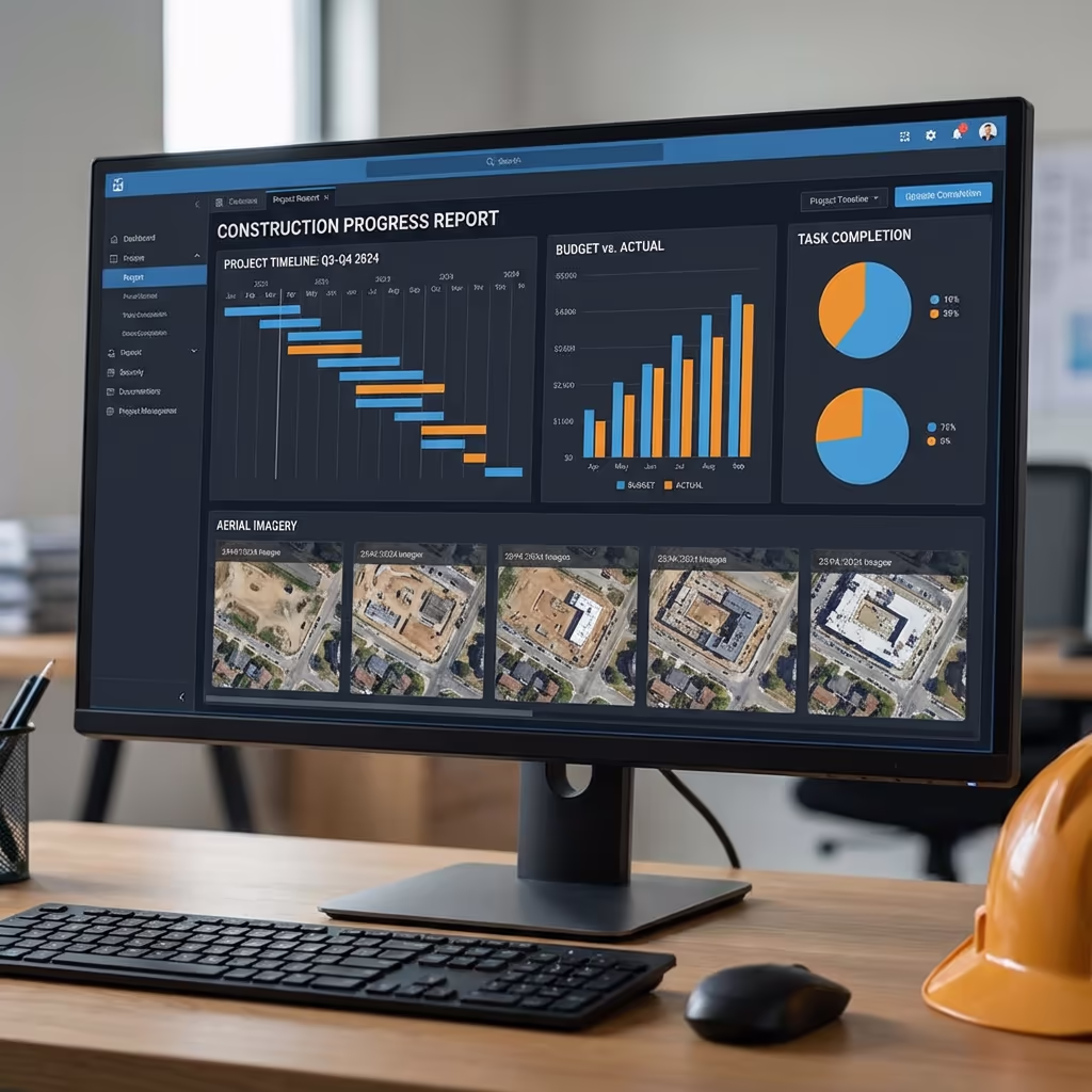
What Deliverables Do You Get From a Drone Solar Farm Survey?
We tailor deliverables to your specific requirements, but our standard drone solar farm survey outputs include:
Thermal Imagery
High-resolution radiometric thermal images of every panel. Calibrated temperature data for accurate defect classification.
Panel Defect Reports
Comprehensive defect register with GPS locations, defect type classification, severity ratings, and recommended actions.
Site Orthomosaic
High-resolution aerial imagery of your entire site. Perfect for site management, vegetation monitoring, and visual condition assessment.
Site Mapping
GIS-compatible mapping with panel locations. Integration with your asset management system for efficient maintenance planning.
Performance Analysis
Statistical summary of defects by type and severity. Estimated energy loss calculations and comparison with previous inspections.
Maintenance Priorities
Prioritised action list based on defect severity and potential energy impact. Clear guidance for your maintenance team or O&M provider.
Need specific deliverables for your project?
How Long Does a Drone Solar Farm Survey Take?
On-site data capture is remarkably efficient. We can survey 50-100MW per day depending on site layout and weather conditions. A typical 20MW solar farm takes just 3-4 hours of flight time, capturing both thermal and RGB imagery of every panel.
Processing and report delivery depends on site size and your required outputs. Standard deliverables are typically ready within 5-7 working days. For urgent projects requiring rapid turnaround, we offer express processing with 48-72 hour delivery available at additional cost.
| Phase | Duration |
|---|---|
| Planning & Scheduling | 1-2 days |
| On-Site Data Capture | ½-1 day |
| Image Processing | 1-2 days |
| Defect Analysis | 2-3 days |
| Report Generation | 1 day |
| Total (Standard) | 5-7 working days |
Express Processing Available
Need it faster? 48-72 hour turnaround available for urgent projects and acquisitions.
How Do I Choose a Drone Solar Farm Survey Provider?
Not all drone solar inspection services are equal. When evaluating providers, we recommend checking these key factors:
- CAA authorisation - Ensure they hold valid GVC or legacy PfCO permissions for commercial operations
- Radiometric thermal cameras - Not all thermal cameras provide calibrated temperature data essential for accurate analysis
- Solar industry experience - Understanding of PV defect types and their operational implications
- Professional insurance - Public liability and professional indemnity cover appropriate for solar asset work
- Clear reporting - Reports that integrate with your asset management systems and O&M workflows
At Drone Survey Services, we tick every box. We're CAA approved, fully insured, and have delivered solar farm inspections for asset owners, investors, and O&M providers across the UK.
Ready to work with a trusted solar inspection provider?
Is Drone Solar Farm Survey Cheaper Than Manual Inspection?
Significantly cheaper in almost all cases. Traditional manual inspection of a 20MW solar farm might take a team of technicians a full week, with associated labour, equipment hire, and health & safety costs. Our drone survey captures the same site in hours.
The cost savings typically range from 60-80% compared to traditional panel-by-panel inspection, while delivering more comprehensive data. Every panel is inspected from a consistent angle with calibrated thermal sensors - something manual inspection simply cannot match. For portfolio owners with multiple sites, the economics become even more compelling with multi-site contracts.
Ready to Discuss Your Solar Farm Inspection?
Expert advice - Tailored pricing - Response within 2 hours
James Leslie
Owner, Engineer & Drone Pilot
With extensive experience in surveying and UAV operations, James personally oversees every solar farm inspection to ensure accurate defect detection and professional delivery.
TLDR: Drone Solar Farm Survey Explained
Solar Survey Deliverables
- Thermal imagery
- Panel defect reports
- Orthomosaic
- Site mapping
- Performance analysis
- Maintenance priorities
Discuss Your Project
Get expert advice and tailored pricing.
Enterprise Equipment
Survey-Grade Drone Fleet
We don't use consumer mini drones like other providers. Our fleet consists of industrial, survey-grade aircraft purpose-built for capturing detailed, accurate datasets.

AgEagle eBee X
Professional fixed-wing for rapid terrain coverage

DJI Matrice 400
Engineered for excellence, designed for versatility

WingtraOne GEN II
Best-in-class surveying efficiency for large projects

DJI Matrice 350 RTK
Professional multi-payload platform for precision surveying

DJI Mavic 4E
Portable surveying powerhouse with RTK precision
DJI Matrice 300 RTK
Industry-leading inspection and mapping platform

DJI Matrice 4E
Precision survey drone with oblique capture
1 of 7
← Swipe to explore fleet →
Sensor Technology
Specialised Sensors for All Aerial Surveys
Our aircraft carry professional-grade sensors matched to your project requirements, from high-resolution photogrammetry to terrain-penetrating LiDAR.
LiDAR Sensors
Penetrate vegetation and capture precise terrain data with laser scanning technology.
Applications
- Forestry & vegetation mapping
- Terrain modelling under canopy
- Flood risk assessment
- Archaeological surveys
- Power line corridor mapping
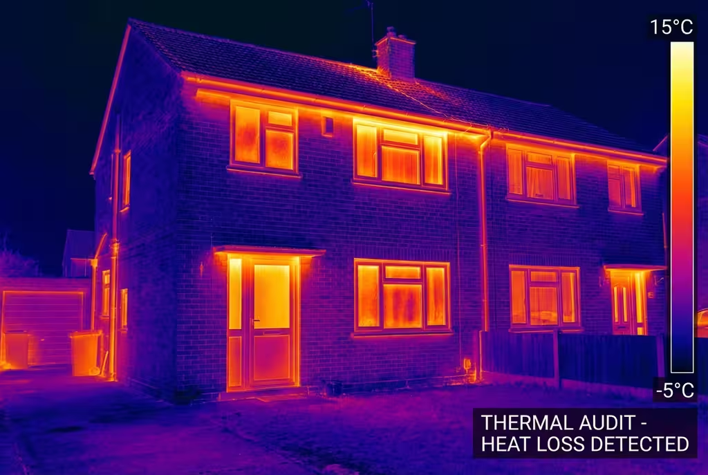
Thermal Imaging
Detect heat signatures for building diagnostics, energy audits, and industrial inspections.
Applications
- Building thermal surveys
- Solar panel inspections
- Electrical fault detection
- Search and rescue
- Livestock monitoring
RGB & Photogrammetry
High-resolution imagery for detailed 3D models, orthomosaics, and visual inspections.
Applications
- Topographic surveys
- 3D model generation
- Progress monitoring
- Asset inspection
- Marketing photography
Need a specific sensor or payload?
Client Testimonials
Why Clients Rate Our Drone Survey Service 5 Stars
Don't just take our word for it. Here's what industry professionals say about working with us.
“By far the best drone surveying company I've used. Responsive, helpful and report quality is spot on. Extremely diligent in highlighting defects outside of scope. 10+ projects completed and never disappointed.”
Mark Reynolds
Building Surveyor
“DSS's drone roof survey was brilliant. James showed me everything wrong with my roof in about 30 minutes. Quick, professional and easy to understand.”
Helen Parker
Homeowner
“Fantastic company to do business with. Been working with the DSS team since 2021 and it's been an absolute pleasure. Highly recommended.”
Robert Hughes
Property Developer