Infrastructure & Utilities
Drone Utility Survey Services
Comprehensive aerial surveys for power lines, pipelines, and utility infrastructure. Safer, faster, and more cost-effective than traditional inspection methods.
Response within 2 hours • Or call 020 4634 0456
What Is a Drone Utility Survey?
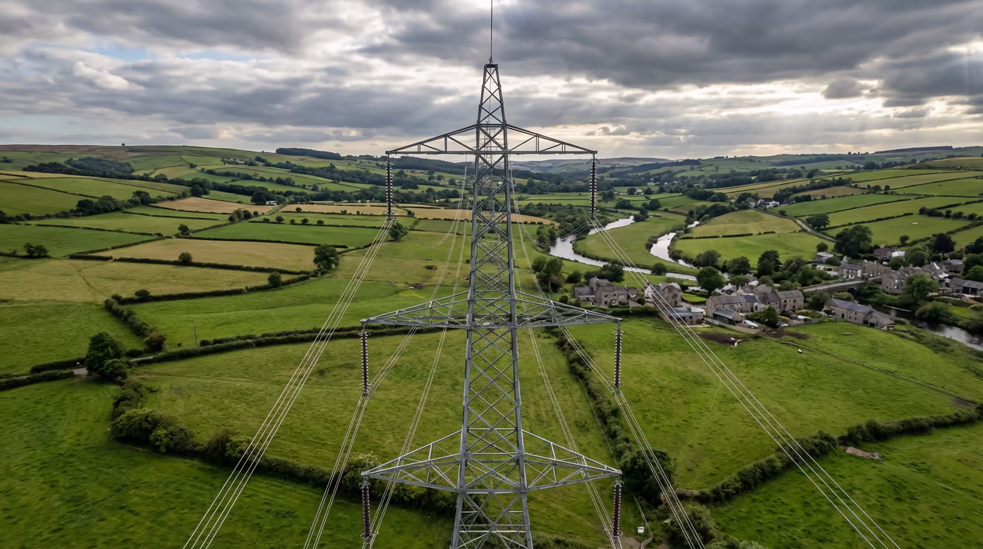
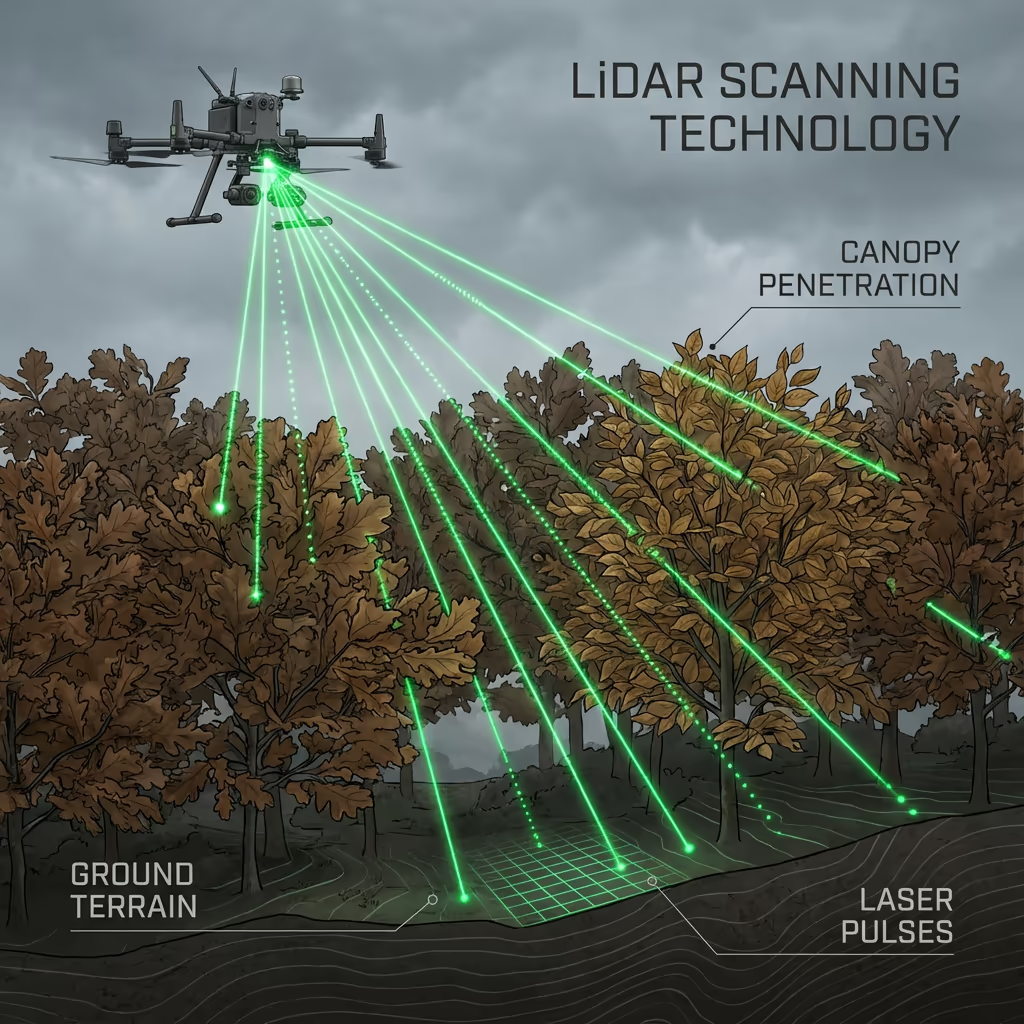
A drone utility survey uses advanced UAV technology to inspect, map, and assess utility infrastructure including power lines, transmission towers, pipelines, substations, and telecommunications equipment. Our drones capture high-resolution imagery and LiDAR data that reveals asset condition, clearance distances, and vegetation encroachment risks.
At Drone Survey Services, we deploy specialist sensors optimised for utility corridor surveys. Our systems can detect conductor sag, insulator damage, corrosion, and vegetation proximity issues that might go unnoticed during traditional ground inspections—all without the need for costly outages or workers at height.

James Leslie
Owner, Engineer & Drone Pilot
"Got questions? Call me directly - I'm happy to talk through your project."
Call NowSurvey-Grade Drone Utility Data,Delivered Fast
What You'll Receive
- Detailed corridor mapping
- Vegetation encroachment analysis
- Asset condition reports
- Clearance measurements
Delivered in 5-7 working days
Why Choose Us
- CAA approved & fully insured
- Specialist utility sector experience
- Latest drone & sensor technology
- UK-wide coverage
Trusted by utility companies, network operators & infrastructure managers across the UK.
Trusted by leading organisations
How Much Does a Drone Utility Survey Cost?
Pricing depends on corridor length, asset complexity, and required deliverables. Here's a guide to help you budget:
| Project Size | Guide Price |
|---|---|
| Short CorridorUnder 5 km | £1,200+ |
| Medium5–20 km | £2,500+ |
| Long Corridor20–50 km | £5,000+ |
| Major Network50+ km | POA |
| Asset InspectionSingle assets | POA |
*Guide prices include standard deliverables. Final quote based on corridor complexity, access, and specific requirements.
What affects your quote?
- Corridor length & terrain
- Asset types & density
- Turnaround time
- Airspace restrictions
Our drone-based approach typically saves 50–70% compared to traditional helicopter surveys or manned inspections. Contact us with your project details and we'll provide a tailored quote within 24 hours.
Ready to get a quote for your project?
Free, no-obligation quotes within 24 hours
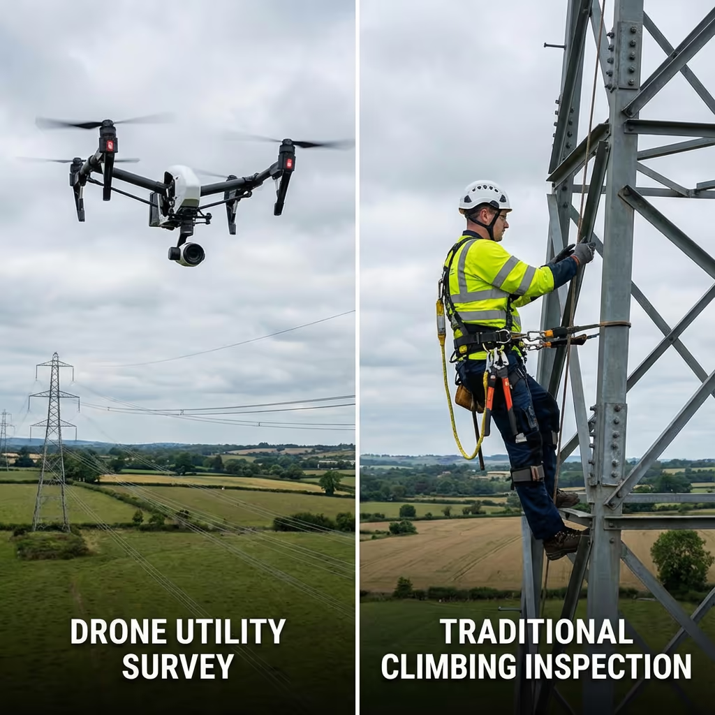
What Is the Difference Between Drone Utility Survey and Traditional Methods?
Traditional utility inspections typically involve ground patrols, helicopter surveys, or workers climbing structures—all with significant cost, safety, and efficiency limitations. Drones offer a transformative alternative that addresses all these challenges.
Our drone utility surveys can cover extensive corridors in a single day, capturing detailed imagery of every asset without requiring shutdowns or putting workers at height. The captured data is more comprehensive than visual inspections, and can be reviewed, measured, and analysed repeatedly from the office.
When to Choose Each Approach
Choose Drone Utility Survey
Faster, safer, more detailed
Traditional Methods
Ground & helicopter surveys
Not sure which approach suits your infrastructure?
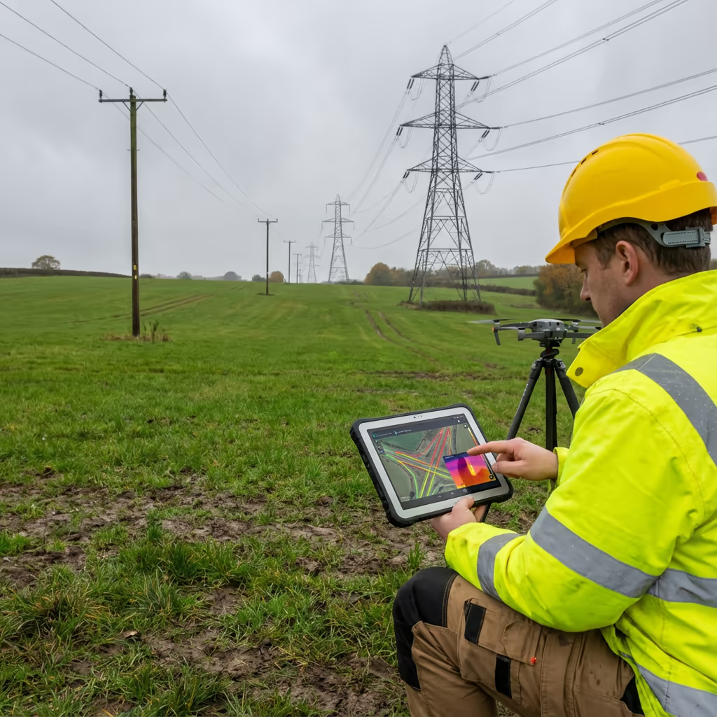
What Accuracy Can a Drone Utility Survey Achieve?
Our drone utility surveys achieve clearance measurement accuracy of ±5-10cm using combined LiDAR and photogrammetry techniques. This exceeds the requirements for vegetation management planning and regulatory compliance reporting.
For conductor sag analysis and thermal imaging, we deploy specialist sensors calibrated for power line inspection. RTK/PPK positioning ensures every measurement is precisely georeferenced, allowing accurate comparison with design specifications and tracking of changes over time.
What Are the Applications of Drone Utility Survey?
Drone utility surveys have revolutionised how infrastructure operators inspect and manage their assets. Here are the key applications where our clients see the greatest value:
Power Line Inspection
Transmission and distribution line surveys including conductor condition, insulator damage, hardware corrosion, and connection integrity.
Vegetation Management
Identify trees and vegetation that pose encroachment risks, prioritise clearance works, and document compliance with statutory requirements.
Pipeline Corridors
Oil, gas, and water pipeline route surveys for ground movement, third-party encroachment, and easement monitoring.
Substation Surveys
Comprehensive aerial inspection of substations, switchyards, and transformer compounds including thermal anomaly detection.
Telecommunication Assets
Mast and tower inspections, antenna alignment verification, and structural condition assessment for mobile and broadcast infrastructure.
Rail Electrification
Overhead line equipment surveys, catenary inspections, and clearance verification for railway electrification projects.
Have utility infrastructure that needs surveying?
Can Drones Detect Vegetation Encroachment?
Yes—vegetation encroachment detection is one of the most valuable applications of drone utility surveys. Our LiDAR and photogrammetry systems create precise 3D models of both vegetation canopy and power line conductors, allowing us to measure exact clearance distances at every point along the corridor.
We can identify trees that are currently encroaching, predict which will require attention based on growth rates, and prioritise vegetation management programmes based on risk. The data integrates directly with GIS systems used by utility vegetation management teams, enabling efficient scheduling and compliance documentation.
What Deliverables Do You Get From a Drone Utility Survey?
We tailor deliverables to your operational requirements, but our standard drone utility survey outputs include:
Corridor Mapping
Complete georeferenced survey of your utility corridor with all assets, structures, and access points documented.
Clearance Analysis
Precise measurements of conductor-to-ground and conductor-to-vegetation clearances with compliance status.
Vegetation Reports
Detailed vegetation encroachment analysis with risk ratings, prioritised work schedules, and GIS-compatible data.
Asset Condition Reports
Visual inspection reports for towers, poles, insulators, and hardware with defect identification and severity ratings.
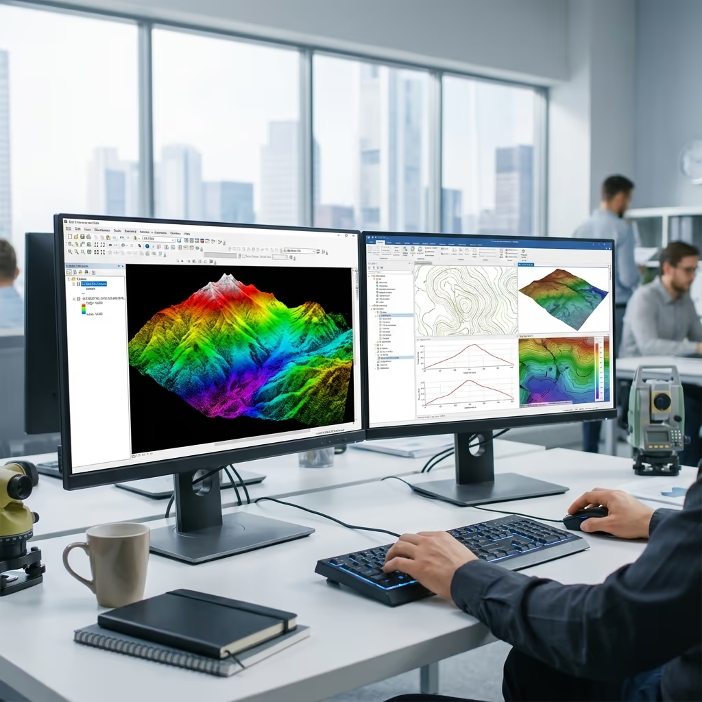
3D Models & CAD Files
Point clouds, 3D mesh models, and CAD-ready drawings for engineering analysis and design work.
Need specific deliverables for your project?
How Long Does a Drone Utility Survey Take?
Our drones can survey 20-40 km of utility corridor per day depending on terrain and asset density. A typical 15 km distribution line survey can be completed in a single day of flying, with minimal disruption to your operations.
Data processing and report delivery depends on project scope and your required outputs. Standard deliverables are typically ready within 5-7 working days. For urgent projects or time-critical inspections, we offer expedited processing with 48-72 hour turnaround available.
| Phase | Duration |
|---|---|
| Planning & Permissions | 1-3 days |
| On-Site Data Capture | 1-3 days |
| Data Processing | 2-4 days |
| Analysis & QC | 2-3 days |
| Report Generation | 1-2 days |
| Total (Standard) | 5-7 working days |
Express Processing Available
Need it faster? 48-72 hour turnaround available for urgent projects.
How Do I Choose a Drone Utility Survey Provider?
Not all drone operators have the specialist experience needed for utility sector work. When evaluating providers, we recommend checking these key factors:
- CAA authorisation – Ensure they hold valid GVC permissions for commercial operations near infrastructure
- Utility sector experience – Ask about previous work with power companies and infrastructure operators
- Professional insurance – Public liability and professional indemnity cover appropriate for utility work
- Appropriate equipment – Sensors capable of delivering the accuracy and detail you need
- Data security – Appropriate handling of sensitive infrastructure data
At Drone Survey Services, we tick every box. We're CAA approved, fully insured, and have extensive experience working with utility companies and infrastructure operators across the UK.
Ready to work with a trusted drone utility survey provider?
Is Drone Utility Survey Cheaper Than Traditional Methods?
Significantly. Traditional utility inspections carry high costs for good reason—helicopter surveys require expensive aircraft, pilots, and extensive safety protocols. Ground-based patrols are slow and labour-intensive. Climbing inspections require specialist crews, equipment, and often service outages.
Our drone-based approach delivers better data at a fraction of the cost. Typical savings range from 50-70% compared to helicopter surveys, and 40-60% compared to traditional climbing inspections. The speed advantage also means faster turnaround—critical when you need to respond to faults or plan maintenance programmes.
Ready to Discuss Your Drone Utility Survey?
Expert advice • Tailored pricing • Response within 2 hours
James Leslie
Owner, Engineer & Drone Pilot
With extensive experience in surveying and UAV operations, James personally oversees every utility survey project to ensure professional delivery and accurate results.
TLDR: Drone Utility Surveys Explained
Drone Utility Survey Deliverables
- Corridor mapping
- Clearance analysis
- Vegetation reports
- Asset condition
- 3D models
- CAD files
Discuss Your Project
Get expert advice and tailored pricing.
Enterprise Equipment
Survey-Grade Drone Fleet
We don't use consumer mini drones like other providers. Our fleet consists of industrial, survey-grade aircraft purpose-built for capturing detailed, accurate datasets.

AgEagle eBee X
Professional fixed-wing for rapid terrain coverage

DJI Matrice 400
Engineered for excellence, designed for versatility

WingtraOne GEN II
Best-in-class surveying efficiency for large projects

DJI Matrice 350 RTK
Professional multi-payload platform for precision surveying

DJI Mavic 4E
Portable surveying powerhouse with RTK precision
DJI Matrice 300 RTK
Industry-leading inspection and mapping platform

DJI Matrice 4E
Precision survey drone with oblique capture
1 of 7
← Swipe to explore fleet →
Sensor Technology
Specialised Sensors for All Aerial Surveys
Our aircraft carry professional-grade sensors matched to your project requirements, from high-resolution photogrammetry to terrain-penetrating LiDAR.
LiDAR Sensors
Penetrate vegetation and capture precise terrain data with laser scanning technology.
Applications
- Forestry & vegetation mapping
- Terrain modelling under canopy
- Flood risk assessment
- Archaeological surveys
- Power line corridor mapping
Thermal Imaging
Detect heat signatures for building diagnostics, energy audits, and industrial inspections.
Applications
- Building thermal surveys
- Solar panel inspections
- Electrical fault detection
- Search and rescue
- Livestock monitoring
RGB & Photogrammetry
High-resolution imagery for detailed 3D models, orthomosaics, and visual inspections.
Applications
- Topographic surveys
- 3D model generation
- Progress monitoring
- Asset inspection
- Marketing photography
Need a specific sensor or payload?
Client Testimonials
Why Clients Rate Our Drone Survey Service 5 Stars
Don't just take our word for it. Here's what industry professionals say about working with us.
“By far the best drone surveying company I've used. Responsive, helpful and report quality is spot on. Extremely diligent in highlighting defects outside of scope. 10+ projects completed and never disappointed.”
Mark Reynolds
Building Surveyor
“DSS's drone roof survey was brilliant. James showed me everything wrong with my roof in about 30 minutes. Quick, professional and easy to understand.”
Helen Parker
Homeowner
“Fantastic company to do business with. Been working with the DSS team since 2021 and it's been an absolute pleasure. Highly recommended.”
Robert Hughes
Property Developer