Surveying & Mapping
Drone Volumetric Survey Services
Precise stockpile measurements and volume calculations using aerial drone technology. Faster, safer, and more accurate than traditional methods.
Response within 2 hours • Or call 020 4634 0456
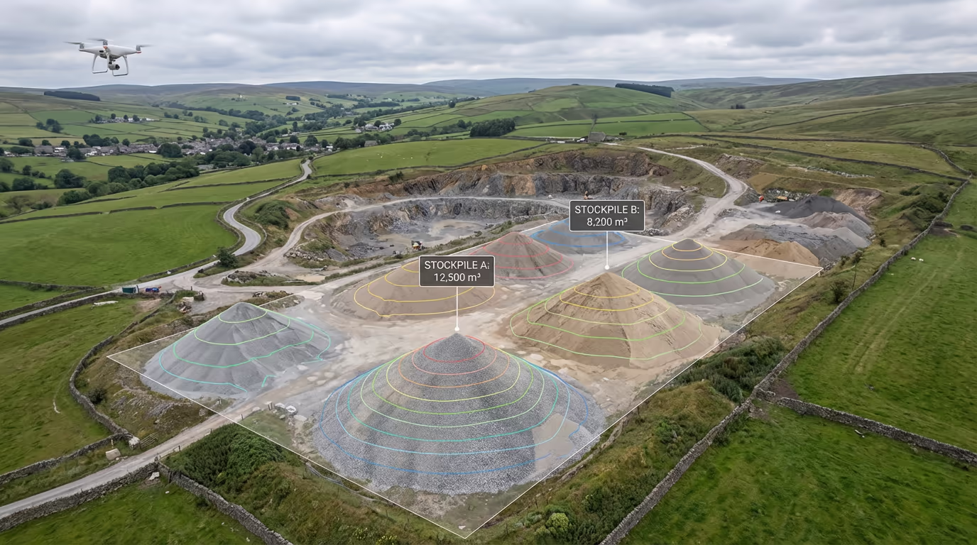
What Is a Drone Volumetric Survey?
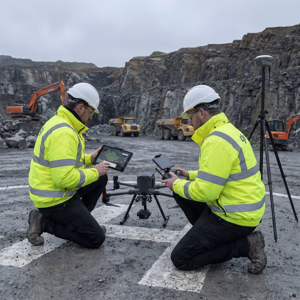
A drone volumetric survey uses aerial photogrammetry to calculate the precise volume of stockpiles, excavations, and earth movements. Our drones capture hundreds of overlapping images that are processed into detailed 3D models, from which accurate volume measurements are extracted automatically.
At Drone Survey Services, we deliver volumetric surveys that achieve 1-3% accuracy—often exceeding the precision of traditional ground-based methods. Whether you're measuring aggregate stockpiles at a quarry, tracking earthworks progress on a construction site, or reconciling material inventory, our drone surveys provide the data you need quickly and safely.

James Leslie
Owner, Engineer & Drone Pilot
"Got questions? Call me directly - I'm happy to talk through your project."
Call NowAccurate Volume Data,Delivered Fast
What You'll Receive
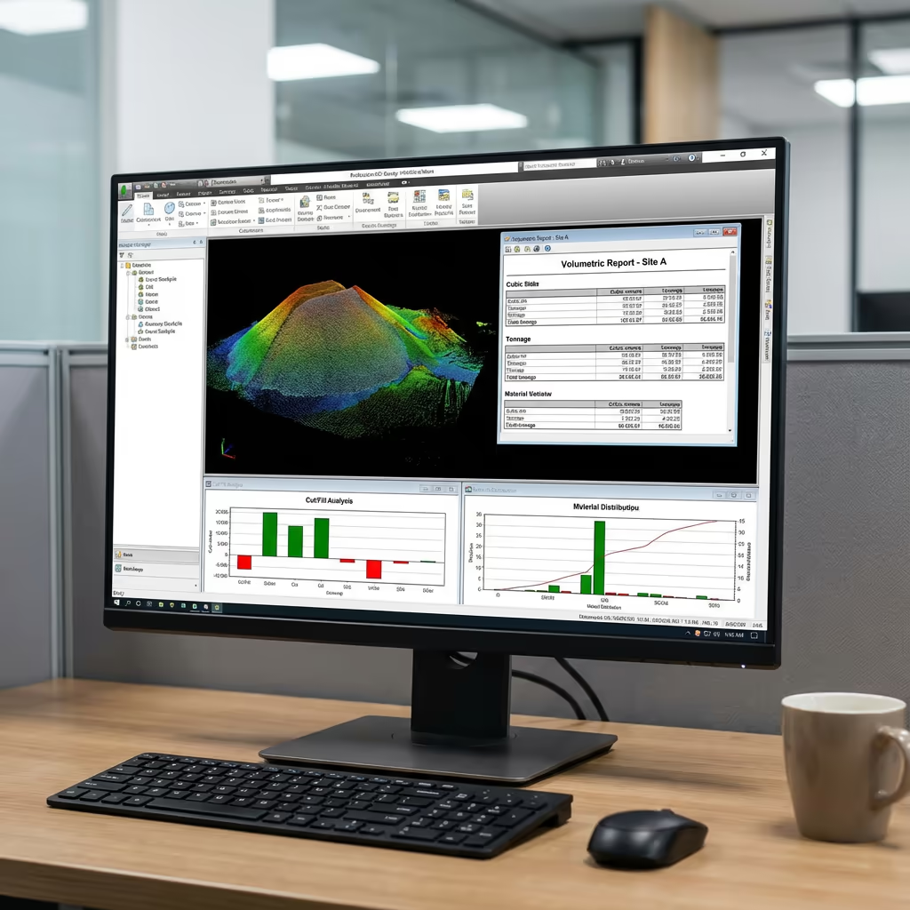
- Certified volume reports (PDF)
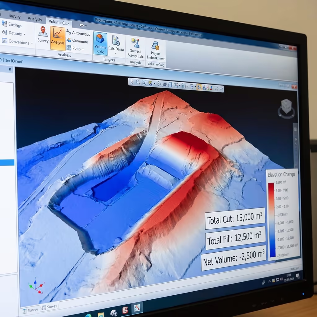
- Cut/fill analysis with colour maps
- 3D stockpile models (OBJ/mesh)
- 1-3% measurement accuracy
Delivered in 3-5 working days
Why Choose Us
- CAA approved & fully insured
- Specialist volumetric processing
- Latest DJI survey equipment
- UK-wide coverage
Trusted by quarries, construction companies & material suppliers across the UK.
Trusted by leading organisations
How Much Does a Drone Volumetric Survey Cost?
Pricing depends on the number of stockpiles and site complexity. Here's a guide to help you budget:
| Project Size | Guide Price |
|---|---|
| Single Stockpile1 pile | £400+ |
| Small Site2-5 piles | £600+ |
| Medium Site5-10 piles | £900+ |
| Large Site10-20 piles | £1,400+ |
| Recurring MonthlyRegular surveys | POA |
| EnterpriseMulti-site | POA |
*Guide prices include standard deliverables. Final quote based on site access, stockpile size, and specific requirements.
What affects your quote?
- Number of stockpiles
- Site access & safety
- Turnaround time
- Recurring frequency
Our drone volumetric surveys typically cost 50-70% less than traditional surveying methods while delivering results in a fraction of the time. Contact us with your requirements and we'll provide a tailored quote within 24 hours.
Ready to get a quote for your project?
Free, no-obligation quotes within 24 hours
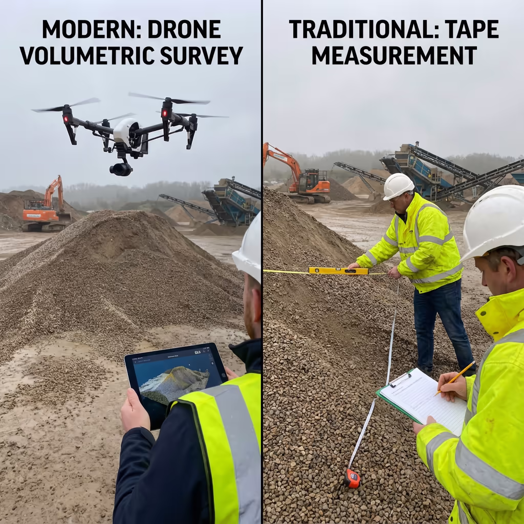
What Is the Difference Between Drone Volumetric Survey and Traditional Measurement?
Traditional stockpile measurement relies on physical tape measurements, GPS surveys with rod shots, or wheel-based methods. Surveyors must physically walk around and over stockpiles—a time-consuming process that creates safety risks and often misses irregular shapes and surface variations.
Drone volumetric surveys capture thousands of surface points without anyone stepping onto the stockpile. Our aerial approach creates complete 3D models that account for every bump, slope, and irregularity. The result is faster data collection, improved safety, and measurements that are typically more accurate than ground-based methods.
Comparison at a Glance
Drone Volumetric Survey
Modern approach
Traditional Methods
Ground-based approach
Want to see how much you could save?
What Accuracy Can a Drone Volumetric Survey Achieve?
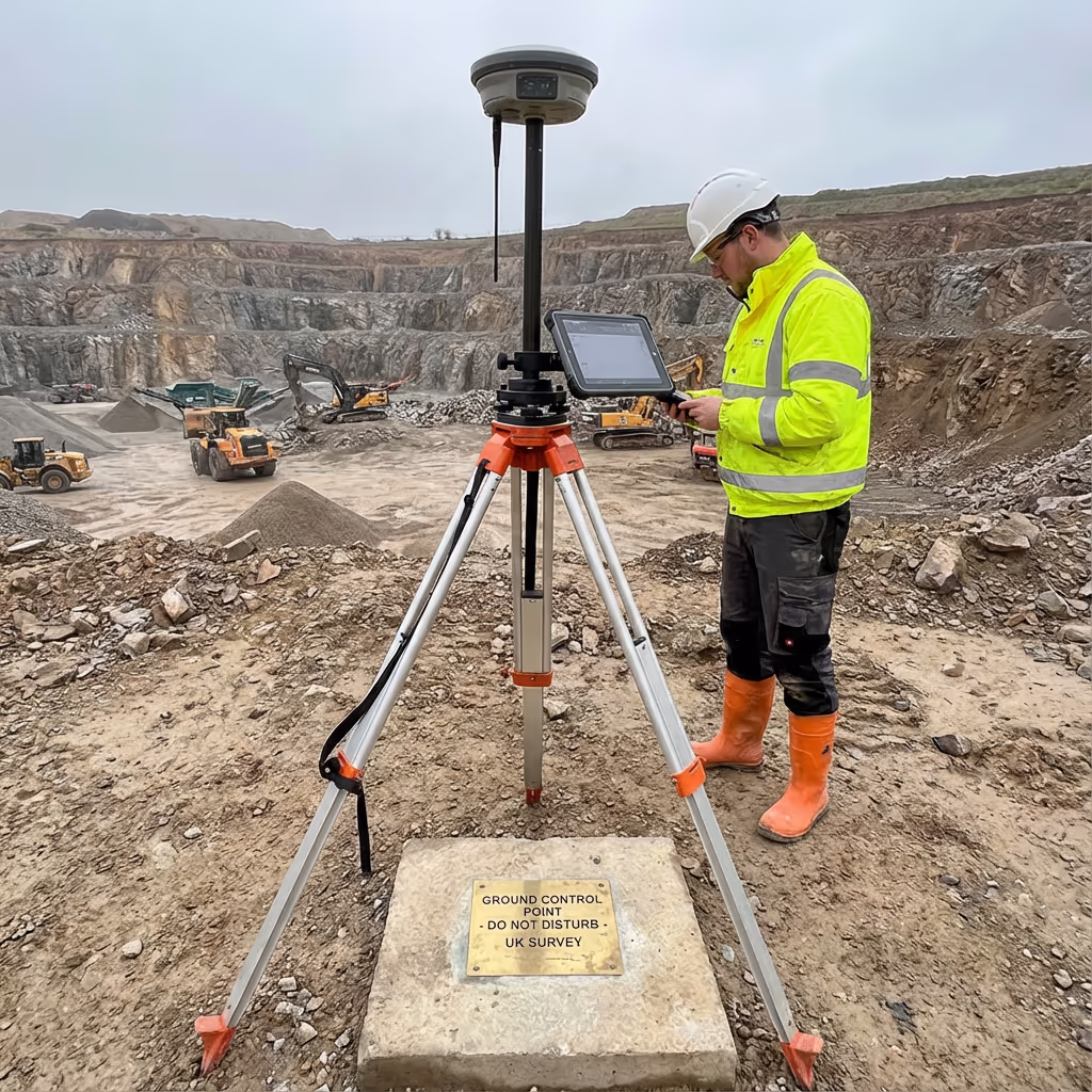
Our drone volumetric surveys consistently achieve 1-3% accuracy on volume measurements. This level of precision meets or exceeds the requirements for inventory management, financial reporting, and regulatory compliance across the aggregates and mining industries.
We achieve this accuracy through RTK/PPK-enabled drones, strategic ground control point placement, and rigorous processing workflows. Every survey is quality-checked against known volumes and control points before delivery. For clients requiring the highest accuracy, we can implement enhanced ground control networks to push accuracy below 1%.
What Are the Applications of Drone Volumetric Survey?
Drone volumetric surveys serve a wide range of industries where accurate volume measurement is critical for operations, compliance, or financial reporting:
Quarries & Mining
Stock inventory, extraction tracking, reserve calculations, and royalty verification for aggregates, sand, gravel, and mineral operations.
Construction Sites
Cut/fill calculations, earthworks progress monitoring, material tracking, and contractor verification for civil engineering projects.
Waste & Recycling
Landfill capacity monitoring, waste volume tracking, regulatory compliance reporting, and void space calculations.
Ports & Logistics
Bulk cargo measurement, coal and ore stockpiles, inventory management, and shipping verification.
Agriculture
Silage clamps, grain stores, fertiliser stockpiles, and crop residue volumes for farm management.
Material Suppliers
Builders merchants, concrete plants, and material yards requiring regular stock audits and inventory verification.
Need accurate volume measurements?
How Accurate Are Drone Volume Measurements?
Drone volumetric measurements achieve remarkable accuracy—typically within 1-3% of actual volumes. This level of precision comes from the combination of high-resolution photogrammetry, precise GPS positioning, and sophisticated 3D modelling software that captures the true surface of every stockpile.
Independent studies have shown drone surveys consistently outperform traditional tape and GPS rod methods, which typically achieve only 5-15% accuracy. The key advantage is coverage: while traditional methods sample a limited number of points, drone surveys capture millions of surface points that define the complete shape of each stockpile.
Accuracy Comparison
1-3%
Drone Survey
5-10%
GPS Rod
10-15%
Tape Measure
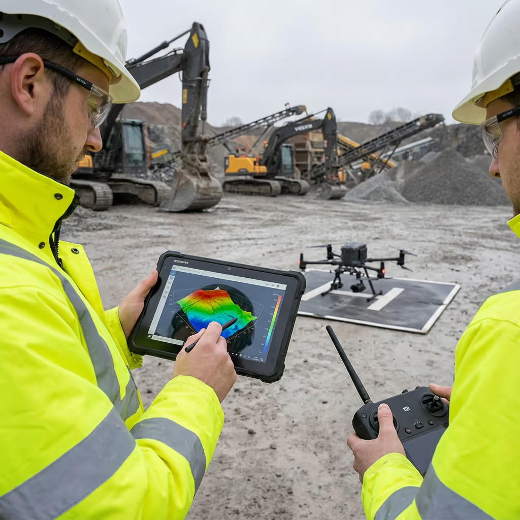
What Deliverables Do You Get From a Drone Volumetric Survey?
We tailor deliverables to your requirements, but our standard volumetric survey outputs include:
Volume Reports (PDF)
Certified volume calculations for each stockpile with methodology, accuracy statements, and summary tables ready for audits.
Cut/Fill Analysis
Colour-coded maps showing volume changes between surveys. Essential for tracking earthworks progress and material movement.
3D Stockpile Models
Detailed mesh models (OBJ format) that can be viewed in standard 3D software or imported into your management systems.
Orthomosaic Maps
High-resolution aerial imagery of your site, georeferenced and ready for GIS software or simple visual reference.
Reconciliation Data
Material movement analysis comparing surveyed volumes with sales/delivery records to identify discrepancies.
Need specific deliverables for your project?
How Long Does a Drone Volumetric Survey Take?
On-site data capture is remarkably fast. A typical site with 5-10 stockpiles can be surveyed in 1-2 hours, including setup and ground control. Even large quarries with 20+ stockpiles rarely take more than half a day.
Processing and delivery depends on project complexity. Standard volume reports are typically ready within 3-5 working days. For urgent requirements, we offer express processing with 24-48 hour turnaround available at additional cost.
| Phase | Duration |
|---|---|
| Planning & Booking | 1-2 days |
| On-Site Survey | 1-4 hours |
| Data Processing | 1-2 days |
| Volume Calculation | 1 day |
| Report Generation | 1 day |
| Total (Standard) | 3-5 working days |
Express Processing Available
Need it faster? 24-48 hour turnaround available for urgent projects.
How Do I Choose a Drone Volumetric Survey Provider?
Not all drone survey providers have the expertise for accurate volumetric work. When evaluating providers, check these key factors:
- CAA authorisation – Ensure they hold valid GVC or legacy PfCO permissions for commercial operations
- Professional insurance – Public liability and professional indemnity cover appropriate to your industry
- Volumetric experience – Ask specifically about stockpile measurement accuracy and methodology
- RTK/PPK capability – Essential for achieving the accuracy required for financial reporting
- Industry references – Request testimonials from similar operations in your sector
At Drone Survey Services, we tick every box. We're CAA approved, fully insured, and have delivered volumetric surveys for quarries, construction sites, and material suppliers throughout the UK. Our RTK-enabled equipment and rigorous processing workflows ensure the accuracy your business depends on.
Ready to work with a trusted volumetric survey provider?
Is Drone Volumetric Survey Cheaper Than Traditional Methods?
Yes—significantly in most cases. Traditional volumetric surveys require surveyors to physically measure stockpiles using tape measures, GPS rovers, or laser equipment. This is time-consuming, labour-intensive, and often requires multiple site visits for large yards.
Our drone surveys capture the same data in a fraction of the time. A site that might take a ground team a full day can be surveyed in hours. The cost savings typically range from 50-70% compared to traditional methods, while delivering faster turnaround and often better accuracy. For recurring surveys, the economics become even more favourable with our monthly packages.
Ready to Discuss Your Volumetric Survey?
Expert advice • Tailored pricing • Response within 2 hours
James Leslie
Owner, Engineer & Drone Pilot
With extensive experience in surveying and UAV operations, James personally oversees every volumetric project to ensure measurement accuracy and professional delivery.
TLDR: Drone Volumetric Survey Explained
Volumetric Deliverables
- Volume reports (PDF)
- Cut/fill analysis
- 3D stockpile models
- Change detection
- Orthomosaics
- Reconciliation data
Discuss Your Project
Get expert advice and tailored pricing.
Enterprise Equipment
Survey-Grade Drone Fleet
We don't use consumer mini drones like other providers. Our fleet consists of industrial, survey-grade aircraft purpose-built for capturing detailed, accurate datasets.

AgEagle eBee X
Professional fixed-wing for rapid terrain coverage

DJI Matrice 400
Engineered for excellence, designed for versatility

WingtraOne GEN II
Best-in-class surveying efficiency for large projects

DJI Matrice 350 RTK
Professional multi-payload platform for precision surveying

DJI Mavic 4E
Portable surveying powerhouse with RTK precision
DJI Matrice 300 RTK
Industry-leading inspection and mapping platform

DJI Matrice 4E
Precision survey drone with oblique capture
1 of 7
← Swipe to explore fleet →
Sensor Technology
Specialised Sensors for All Aerial Surveys
Our aircraft carry professional-grade sensors matched to your project requirements, from high-resolution photogrammetry to terrain-penetrating LiDAR.
LiDAR Sensors
Penetrate vegetation and capture precise terrain data with laser scanning technology.
Applications
- Forestry & vegetation mapping
- Terrain modelling under canopy
- Flood risk assessment
- Archaeological surveys
- Power line corridor mapping
Thermal Imaging
Detect heat signatures for building diagnostics, energy audits, and industrial inspections.
Applications
- Building thermal surveys
- Solar panel inspections
- Electrical fault detection
- Search and rescue
- Livestock monitoring
RGB & Photogrammetry
High-resolution imagery for detailed 3D models, orthomosaics, and visual inspections.
Applications
- Topographic surveys
- 3D model generation
- Progress monitoring
- Asset inspection
- Marketing photography
Need a specific sensor or payload?
Client Testimonials
Why Clients Rate Our Drone Survey Service 5 Stars
Don't just take our word for it. Here's what industry professionals say about working with us.
“By far the best drone surveying company I've used. Responsive, helpful and report quality is spot on. Extremely diligent in highlighting defects outside of scope. 10+ projects completed and never disappointed.”
Mark Reynolds
Building Surveyor
“DSS's drone roof survey was brilliant. James showed me everything wrong with my roof in about 30 minutes. Quick, professional and easy to understand.”
Helen Parker
Homeowner
“Fantastic company to do business with. Been working with the DSS team since 2021 and it's been an absolute pleasure. Highly recommended.”
Robert Hughes
Property Developer