Drone Survey
Comprehensive aerial surveys delivering precise topographic data and 3D models.
Read MoreProfessional Drone Survey Services
Leading UK provider of professional drone surveys, delivering accurate aerial data for construction, infrastructure, and land management projects.
Response within 2 hours • Or call 020 4634 0456
Skip the Hobbyist Headaches
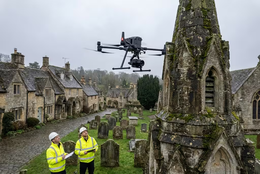
The market is flooded with drone operators promising professional results. Most are hobbyists with consumer DJI Minis and zero surveying knowledge. Companies are tired of receiving unusable datasets that waste time and money.
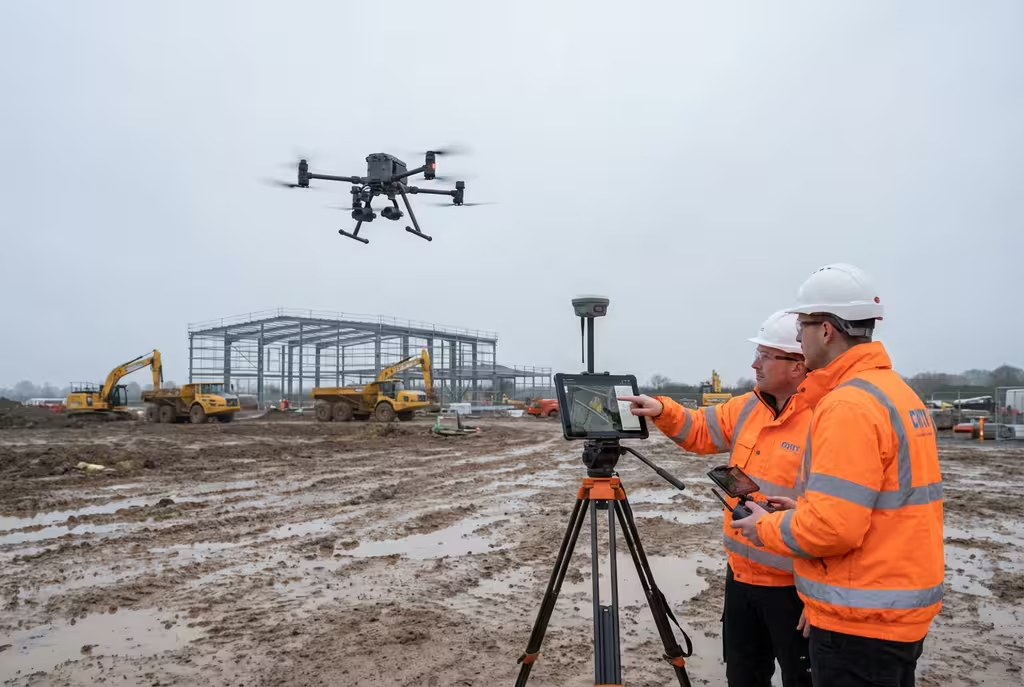
We're different. Our team combines CAA-certified pilots with qualified drone surveyors using enterprise-grade equipment. Every dataset we deliver is accurate, georeferenced, and ready for your workflows.
Survey-Grade GPS
RTK/PPK positioning for ±2cm accuracy
Enterprise Equipment
Matrice 300/350, LiDAR, multispectral
Deliverable Guarantee
Data you can actually use, first time
Surveying Expertise
Qualified surveyors, not just pilots
Get a free quote for your drone survey requirements
Trusted by leading organisations:
10+ Years
Industry Experience
Who We Are
Drone Survey Services (DSS) was founded to revolutionise the surveying industry by combining cutting-edge UAV technology with professional surveying expertise.
Our team of CAA-certified drone pilots and drone surveyors have completed over 500 projects across the UK, from construction site monitoring to environmental habitat mapping.
±2cm
Survey Accuracy
CAA
Approved Pilots
UK Wide
Coverage
Comprehensive aerial survey solutions tailored to your industry needs, delivered with precision and professionalism.

As Featured In
Our expertise in professional drone surveying has been featured across national news and industry publications. Our work has been cited in research by Harvard University and the Scottish Government.
Cited in academic research: MDPI • ASCE Library • Medical Xpress • The Journal of mHealth • Archive of Transport
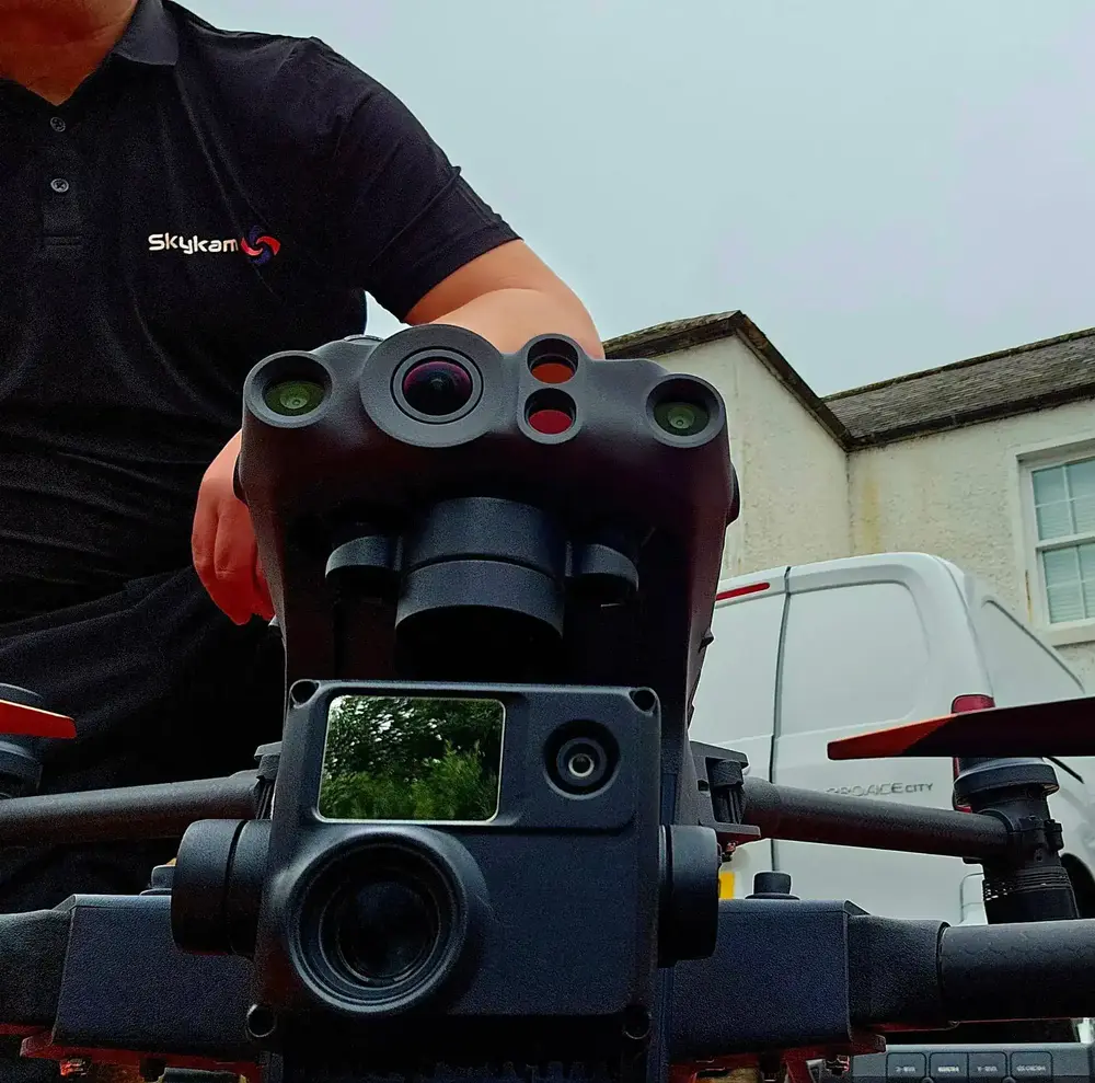
Enterprise Equipment
We don't use consumer mini drones like other providers. Our fleet consists of industrial, survey-grade aircraft purpose-built for capturing detailed, accurate datasets.

Professional fixed-wing for rapid terrain coverage

Engineered for excellence, designed for versatility

Best-in-class surveying efficiency for large projects

Professional multi-payload platform for precision surveying

Portable surveying powerhouse with RTK precision
Industry-leading inspection and mapping platform

Precision survey drone with oblique capture
1 of 7
← Swipe to explore fleet →
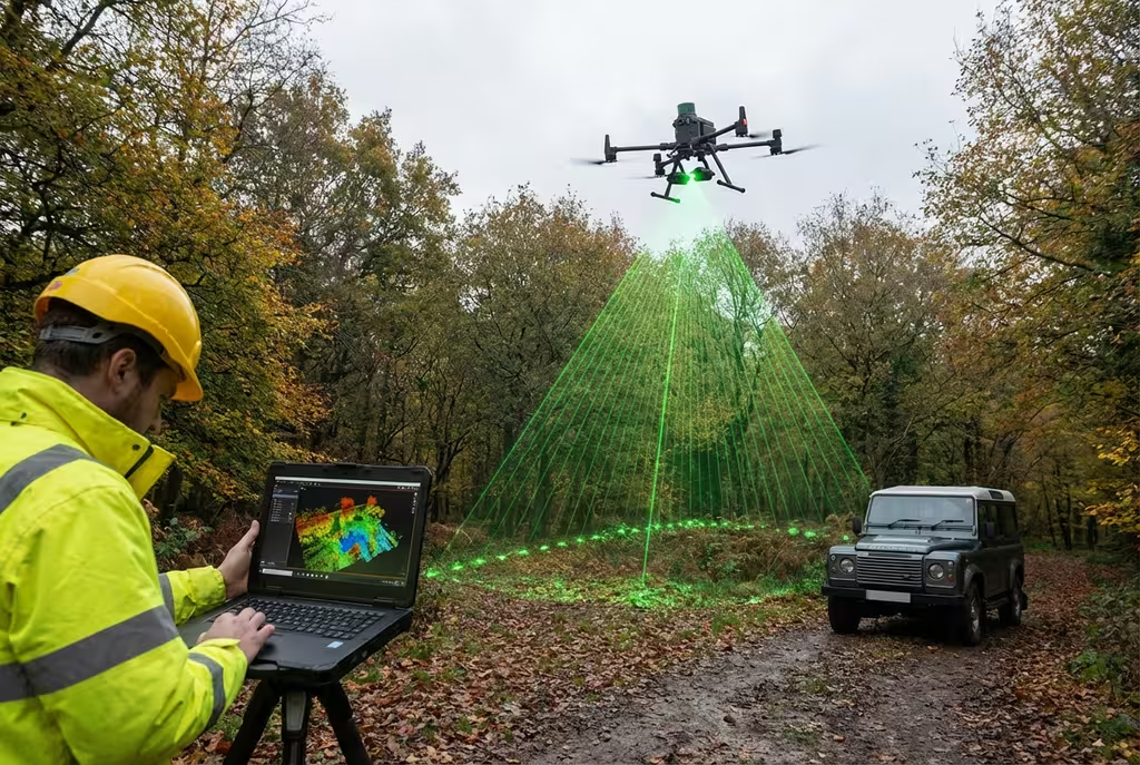
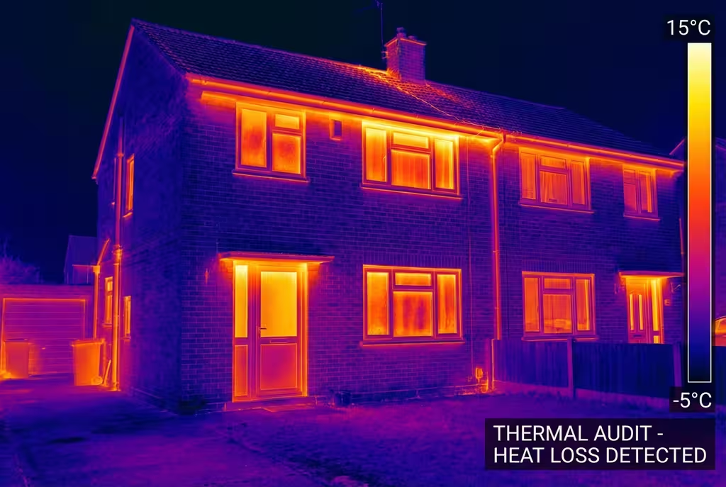
Sensor Technology
Our aircraft carry professional-grade sensors matched to your project requirements, from high-resolution photogrammetry to terrain-penetrating LiDAR.
Penetrate vegetation and capture precise terrain data with laser scanning technology.
Detect heat signatures for building diagnostics, energy audits, and industrial inspections.
High-resolution imagery for detailed 3D models, orthomosaics, and visual inspections.
Need a specific sensor or payload?
Client Testimonials
Don't just take our word for it. Here's what industry professionals say about working with us.
“By far the best drone surveying company I've used. Responsive, helpful and report quality is spot on. Extremely diligent in highlighting defects outside of scope. 10+ projects completed and never disappointed.”
Mark Reynolds
Building Surveyor
“DSS's drone roof survey was brilliant. James showed me everything wrong with my roof in about 30 minutes. Quick, professional and easy to understand.”
Helen Parker
Homeowner
“Fantastic company to do business with. Been working with the DSS team since 2021 and it's been an absolute pleasure. Highly recommended.”
Robert Hughes
Property Developer
From initial consultation to final delivery, our streamlined process ensures efficient and accurate results.
We discuss your project requirements and objectives to determine the best survey approach. Our experts will recommend the optimal drone technology and data outputs for your specific needs.
We discuss your project requirements and objectives to determine the best survey approach. Our experts will recommend the optimal drone technology and data outputs for your specific needs.
Our team plans the flight path, obtains permissions, and prepares all necessary equipment. We handle all CAA regulations, airspace clearances, and site-specific risk assessments.
Our team plans the flight path, obtains permissions, and prepares all necessary equipment. We handle all CAA regulations, airspace clearances, and site-specific risk assessments.
Our CAA-approved pilots capture high-quality aerial data using professional drone equipment. Survey-grade accuracy is achieved through RTK GPS and ground control points.
Our CAA-approved pilots capture high-quality aerial data using professional drone equipment. Survey-grade accuracy is achieved through RTK GPS and ground control points.
Raw data is processed using industry-leading software to create accurate deliverables. Photogrammetry, LiDAR processing, and quality checks ensure precision results.
Raw data is processed using industry-leading software to create accurate deliverables. Photogrammetry, LiDAR processing, and quality checks ensure precision results.
You receive comprehensive reports, maps, and models in your preferred formats. We provide full support to help you integrate the data into your existing workflows.
You receive comprehensive reports, maps, and models in your preferred formats. We provide full support to help you integrate the data into your existing workflows.
Ready to start your project?
We deliver tailored drone survey solutions across a wide range of industries.
Progress monitoring, volumetric analysis, site surveys
Crop health mapping, irrigation planning, yield analysis
Infrastructure inspection, solar farm surveys
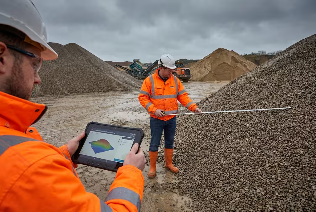
Stockpile volumes, pit surveys, reclamation
Property marketing, boundary surveys, roof inspections
Habitat mapping, flood modelling, conservation
Get a free, no-obligation quote tailored to your specific requirements. Our team responds within 2 hours.
See how drone survey technology compares to conventional survey methods.
Based centrally in the UK, our team provides professional drone survey services to clients across the country. From urban developments in London to remote sites in Scotland, we have the capability and experience to deliver exceptional results wherever your project is located.

500+ projects completed across the UK
Trusted & Certified
Maintaining the highest standards of safety, quality, and compliance with industry-leading certifications.
Public Liability Cover
Comprehensive public liability insurance providing complete peace of mind for all commercial drone operations.
CAA Approved
Fully approved for commercial drone operations with comprehensive compliance to UK aviation regulations and safety standards.
PI Insurance
Full professional indemnity coverage protecting your project investments and deliverables.
Our Certifications & Memberships


Find answers to common questions about our drone survey services.
A drone survey uses unmanned aerial vehicles (UAVs) equipped with cameras and sensors to capture aerial data. This data is then processed using photogrammetry or LiDAR software to create detailed maps, 3D models, and measurements of the surveyed area.
Our drone surveys achieve accuracies of ±2-5cm when using ground control points (GCPs). For projects requiring higher precision, we can achieve sub-centimeter accuracy using RTK-enabled drones and post-processing techniques.
Yes, all our drone pilots hold valid CAA permissions and are fully insured. We operate under GVC (General VLOS Certificate) permissions and can obtain additional permissions for specific operational requirements.
We provide orthomosaic maps, digital elevation models (DEMs), 3D point clouds, textured 3D models, contour maps, volumetric calculations, and detailed survey reports. All deliverables are provided in industry-standard formats.
On-site data capture typically takes a few hours to a full day depending on site size. Processing and delivery of final deliverables usually takes 3-7 working days depending on the complexity and type of outputs required.
Yes, we provide drone survey services nationwide across the UK. Our team is based centrally and we regularly work on projects from Scotland to the South Coast, including both urban and rural locations.
We operate a fleet of professional survey drones including DJI Matrice series with RTK positioning, multi-rotor platforms for detailed inspection work, and fixed-wing aircraft for large area mapping. All drones are equipped with high-resolution cameras or LiDAR sensors.
Yes, our experienced team can obtain special permissions from the CAA and NATS for flights in controlled airspace, near airports, or in other restricted areas. We handle all necessary authorisations as part of our service.
Photogrammetry uses overlapping photographs to create 3D models and is ideal for most survey applications. LiDAR uses laser pulses to measure distances and can penetrate vegetation to capture ground surfaces, making it better for forestry and densely vegetated sites.
Costs vary based on site size, complexity, and deliverables required. As a guide, small site surveys start from around £500, while larger projects are priced per hectare. Contact us for a free, no-obligation quote tailored to your specific requirements.
We typically need access to place ground control points and launch/land the drone safely. However, for some projects we can operate from adjacent land or public areas. We will discuss access requirements during the planning stage.
We can fly in light winds (up to 20mph) and dry conditions. Rain, fog, and strong winds prevent safe operations. We monitor weather forecasts closely and will reschedule if conditions are unsuitable to ensure data quality and safety.
Ready to discuss your drone survey requirements? Complete the form and our team will get back to you within 24 hours with a tailored quote for your project.
Get a free quote for your drone survey requirements